| UR
Urim (Sumerian) / Uru (Akkadian) / Ur (Arabic)
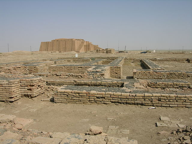
The ruins of Ur, with the Ziggurat of Ur visible in the background
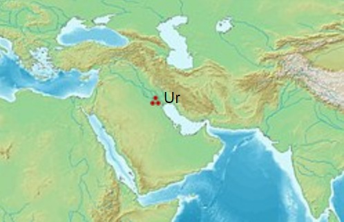
Ur (Sumerian: Urim; Sumerian Cuneiform: Romanized: Uru; Ur) was an important Sumerian city-state in ancient Mesopotamia, located at the site of modern Tell el-Muqayyar in south Iraq's Dhi Qar Governorate. Although Ur was once a coastal city near the mouth of the Euphrates on the Persian Gulf, the coastline has shifted and the city is now well inland, on the south bank of the Euphrates, 16 kilometres (9.9 miles) from Nasiriyah in modern-day Iraq.
The city dates from the Ubaid period circa 3800 BC, and is recorded in written history as a city-state from the 26th century BC, its first recorded king being Mesannepada.
The city's patron deity was Nanna (in Akkadian, Sin), the Sumerian and Akkadian (Assyrian-Babylonian) moon god, and the name of the city is in origin derived from the god's name. UNUGKI, literally "the abode (UNUG) of Nanna".
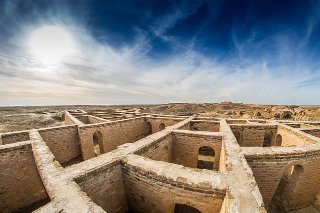
The site is marked by the partially restored ruins of the Ziggurat of Ur, which contained the shrine of Nanna, excavated in the 1930s. The temple was built in the 21st century BC (short chronology), during the reign of Ur-Nammu and was reconstructed in the 6th century BC by Nabonidus, the last king of Babylon. The ruins cover an area of 1,200 metres (3,900 ft) northwest to southeast by 800 metres (2,600 ft) northeast to southwest and rise up to about 20 metres (66 ft) above the present plain level.
Layout :
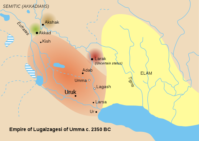
Sumer and Elam circa 2350 BC. Ur is located close to the coastline near the mouth of the Euphrates The city, said to have been planned by Ur-Nammu, was apparently divided into neighbourhoods, with merchants living in one quarter, artisans in another. There were streets both wide and narrow, and open spaces for gatherings. Many structures for water resource management and flood control are in evidence.
Houses were constructed from mudbricks and mud plaster. In major buildings, the masonry was strengthened with bitumen and reeds. For the most part, foundations are all that remain today. People were often buried (separately and alone; sometimes with jewellery, pots, and weapons) in chambers or shafts beneath the house floors.
The name URIM5KI for "Country of Ur" on a seal of King Ur-Nammu Ur was surrounded by sloping ramparts 8 metres high and about 25 metres wide, bordered in some places by a brick wall. Elsewhere, buildings were integrated into the ramparts. The Euphrates River complemented these fortifications on the city's western side.
Society
and culture :
Archaeological study of the region has contributed greatly to our understanding of the landscape and long-distance interactions during these ancient times. Ur was a major port on the Persian Gulf, which extended much further inland than today, and the city controlled much of the trade into Mesopotamia. Imports to Ur came from many parts of the world: precious metals such as gold and silver, and semi-precious stones, namely lapis lazuli and carnelian.
It is thought that Ur had a stratified social system including slaves (captured foreigners), farmers, artisans, doctors, scribes, and priests. High-ranking priests apparently enjoyed great luxury and splendid mansions.
Tens of thousands of cuneiform texts have been recovered from temples, the palace, and individual houses, recording contracts, inventories, and court documents, evidence of the city's complex economic and legal systems.
Music
:
Lizard-headed nude woman nursing a child, from Ur, Ubaid period, 4500-4000 BCE. Iraq Museum
Enthroned King Ur-Nammu (ca. 2047 – 2030 BC)
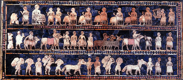
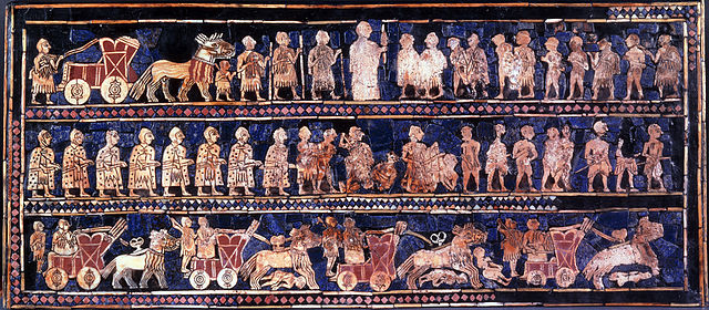
Standard of Ur mosaic (c. 2600 BC)
The Standard of Ur mosaic, from the royal tombs of Ur, is made
of red limestone, bitumen, lapis lazuli, and shell. The "peace"
side shows comfort, music, and prosperity.The "war"
side of the Standard of Ur shows the king, his armies, and chariots
trampling on enemies.
Archaeologists have discovered the evidence of an early occupation at Ur during the Ubaid period (ca. 6500 to 3800 BC). These early levels were sealed off with a sterile deposit of soil that was interpreted by excavators of the 1920s as evidence for the Great Flood of the Book of Genesis and Epic of Gilgamesh. It is now understood that the South Mesopotamian plain was exposed to regular floods from the Euphrates and the Tigris rivers, with heavy erosion from water and wind, which may have given rise to the Mesopotamian and derivative Biblical Great Flood stories.
Sumerian
occupation of the 4th millennium :
The third millennium BC is generally described as the Early Bronze Age of Mesopotamia, which ends approximately after the demise of the Third Dynasty of Ur in the 21st century BC.
Third
millennium BC (Early Bronze Age) :
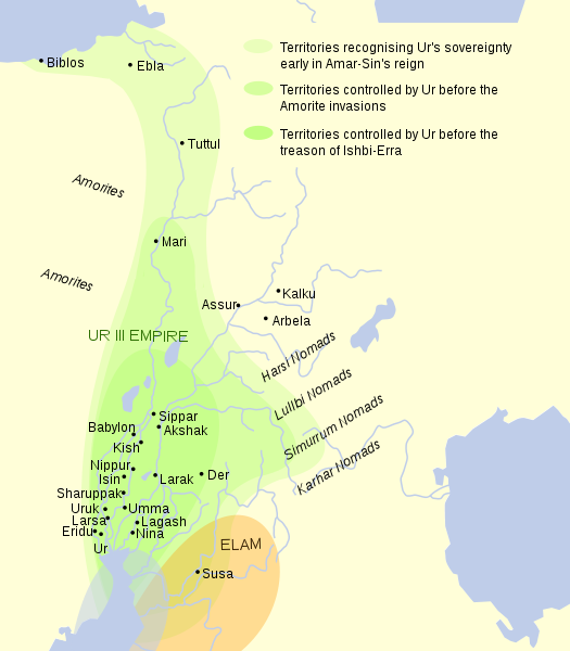
A large body of cuneiform documents, mostly from the empire of the so-called Third Dynasty of Ur (also known as the Neo-Sumerian Empire), appears at the very end of the third millennium. This was the most centralized bureaucratic state the world had yet known.
Ur came under the control of the Semitic-speaking Akkadian Empire founded by Sargon the Great between the 24th and 22nd centuries BC. This was a period when the Semitic-speaking Akkadians, who had entered Mesopotamia in approximately 3000 BC, gained ascendancy over the Sumerians, and indeed much of the ancient Near East.
After the fall of the Akkadian Empire in the mid-22nd century BC, southern Mesopotamia came to be ruled for a few decades by the Gutians, a language isolate-speaking barbarian people originating in the Zagros Mountains to the northeast of Mesopotamia, while the Assyrian branch of the Akkadian speakers reasserted their independence in the north of Mesopotamia.
Empire of the Third Dynasty of Ur. West is at top, north at right
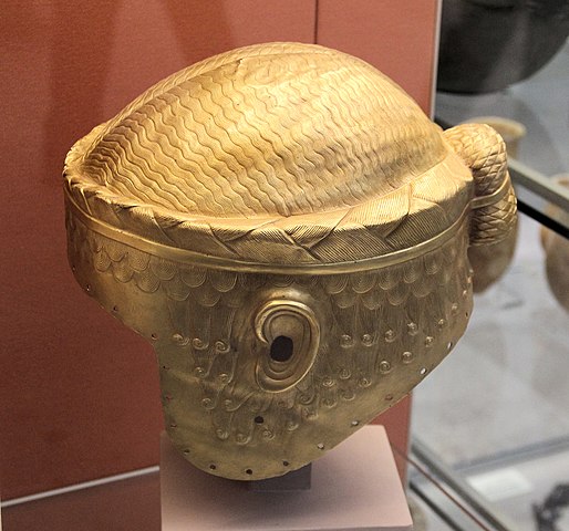
Gold helmet of King of Ur I Meskalamdug, circa 2600 – 2500 BCE
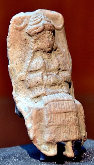
Mesopotamian female deity seated on a chair, Old-Babylonian fired clay plaque from Ur
Ur III :
Ur-Nammu was succeeded by Shulgi, the greatest king of the Third Dynasty of Ur, who solidified the hegemony of Ur and reformed the empire into a highly centralized bureaucratic state. Shulgi ruled for a long time (at least 42 years) and deified himself halfway through his rule.
The Ur empire continued through the reigns of three more kings with Semitic Akkadian names, Amar-Sin, Shu-Sin, and Ibbi-Sin. It fell around 1940 BC to the Elamites in the 24th regnal year of Ibbi-Sin, an event commemorated by the Lament for Ur.
According to one estimate, Ur was the largest city in the world from c. 2030 to 1980 BC. Its population was approximately 65,000 (or 0.1 per cent share of global population then).
Later
Bronze Age :
Iron Age :
From the end of the 7th century BC Ur was ruled by the so-called Chaldean Dynasty of Babylon. In the 6th century BC there was new construction in Ur under the rule of Nebuchadnezzar II of Babylon. The last Babylonian king, Nabonidus (who was Assyrian-born and not a Chaldean), improved the ziggurat. However, the city started to decline from around 530 BC after Babylonia fell to the Persian Achaemenid Empire, and was no longer inhabited by the early 5th century BC. The demise of Ur was perhaps owing to drought, changing river patterns, and the silting of the outlet to the Persian Gulf.
Identification with biblical Ur :
"Abraham's House" in Ur, photographed in 2016 Ur is possibly the city of Ur Kasdim mentioned in the Book of Genesis as the birthplace of the Jewish, Christian and Muslim patriarch Abraham (Ibrahim in Arabic), traditionally believed to have lived some time in the 2nd millennium BC. There are however conflicting traditions and scholarly opinions identifying Ur Kasdim with the sites of Sanliurfa, Urkesh, Urartu or Kutha.
The biblical Ur is mentioned four times in the Torah or Old Testament, with the distinction "of the Kasdim/Kasdin"—traditionally rendered in English as "Ur of the Chaldees". The Chaldeans had settled in the vicinity by around 850 BC, but were not extant anywhere in Mesopotamia during the 2nd millennium BC period when Abraham is traditionally held to have lived. The Chaldean dynasty did not rule Babylonia (and thus become the rulers of Ur) until the late 7th century BC, and held power only until the mid 6th century BC. The name is found in Genesis 11:28, Genesis 11:31, and Genesis 15:7. In Nehemiah 9:7, a single passage mentioning Ur is a paraphrase of Genesis.
Archaeology :
Bitumen "mortar" among Ur mudbricks
Circular groups of bricks excavated in 1900 In 1625, the site was visited by Pietro Della Valle, who recorded the presence of ancient bricks stamped with strange symbols, cemented together with bitumen, as well as inscribed pieces of black marble that appeared to be seals.
European archaeologists did not identify Tell el-Muqayyar as the site of Ur until Henry Rawlinson successfully deciphered some bricks from that location, brought to England by William Loftus in 1849.
The site was first excavated in 1853 and 1854, on behalf of the British Museum and with instructions from the Foreign Office, by John George Taylor, British vice consul at Basra from 1851 to 1859. Taylor uncovered the Ziggurat of Ur and a structure with an arch later identified as part of the "Gate of Judgment".
In the four corners of the ziggurat's top stage, Taylor found clay cylinders bearing an inscription of Nabonidus (Nabuna`id), the last king of Babylon (539 BC), closing with a prayer for his son Belshar-uzur (Bel-sarra-Uzur), the Belshazzar of the Book of Daniel. Evidence was found of prior restorations of the ziggurat by Ishme-Dagan of Isin and Shu-Sin of Ur, and by Kurigalzu, a Kassite king of Babylon in the 14th century BC. Nebuchadnezzar also claims to have rebuilt the temple.
Taylor further excavated an interesting Babylonian building, not far from the temple, part of an ancient Babylonian necropolis. All about the city he found abundant remains of burials of later periods. Apparently, in later times, owing to its sanctity, Ur became a favorite place of sepulchres, so that even after it had ceased to be inhabited, it continued to be used as a necropolis.
Typical of the era, his excavations destroyed information and exposed the tell. Natives used the now loosened, 4,000-year-old bricks and tile for construction for the next 75 years, while the site lay unexplored, the British Museum having decided to prioritize archaeology in Assyria.
After Taylor's time, the site was visited by numerous travelers, almost all of whom have found ancient Babylonian remains, inscribed stones and the like, lying upon the surface. The site was considered rich in remains, and relatively easy to explore. After some soundings were made in 1918 by Reginald Campbell Thompson, H. R. Hall worked the site for one season for the British Museum in 1919, laying the groundwork for more extensive efforts to follow.
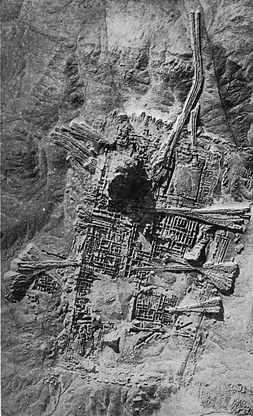
Aerial photograph of Ur in 1927 Excavations from 1922 to 1934 were funded by the British Museum and the University of Pennsylvania and led by the archaeologist Sir Charles Leonard Woolley. A total of about 1,850 burials were uncovered, including 16 that were described as "royal tombs" containing many valuable artifacts, including the Standard of Ur. Most of the royal tombs were dated to about 2600 BC. The finds included the unlooted tomb of a queen thought to be Queen Puabi—the name is known from a cylinder seal found in the tomb, although there were two other different and unnamed seals found in the tomb. Many other people had been buried with her, in a form of human sacrifice. Near the ziggurat were uncovered the temple E-nun-mah and buildings E-dub-lal-mah (built for a king), E-gi-par (residence of the high priestess) and E-hur-sag (a temple building). Outside the temple area, many houses used in everyday life were found. Excavations were also made below the royal tombs layer: a 3.5-metre-thick (11 ft) layer of alluvial clay covered the remains of earlier habitation, including pottery from the Ubaid period, the first stage of settlement in southern Mesopotamia. Woolley later wrote many articles and books about the discoveries. One of Woolley's assistants on the site was the archaeologist Max Mallowan. The discoveries at the site reached the headlines in mainstream media in the world with the discoveries of the Royal Tombs. As a result, the ruins of the ancient city attracted many visitors. One of these visitors was the already famous Agatha Christie, who as a result of this visit ended up marrying Max Mallowan.
During this time the site was accessible from the Baghdad–Basra railway, from a stop called "Ur Junction".
When the Royal Tombs at Ur were first discovered, they had no idea how big they were. They started by digging two trenches in the middle of the desert to see if they could find anything that would allow them to keep digging. They originally split into two teams. Team A and team B. Both teams spent the first few months digging a trench and had found evidence of burial grounds by collecting small pieces of golden jewelry and pottery. This was called at the time the "gold trench" At this time, the first season of digging had come to a close, and Woolley returned to England. In Autumn, Woolley returned and continued to dig into the second season. By the end of the second season, he had uncovered a courtyard surrounded by many rooms. In their third season of digging they had uncovered their biggest find yet, a building that was believed to have been built by the orders of the king, and the second building to be where the high priestess lived. As the fourth and fifth season came to a close, they had discovered so many items, that most of their time was now spent recording the objects they found instead of actually digging objects. They had found many items from gold jewelry to clay pots and stones. There were a few Lyres that were inside of the tombs as well. One of the most significant objects that was discovered was the Standard of Ur. At the end of their sixth season they had excavated 1850 burials and deemed 17 of them to be "Royal Tombs". Woolley had finished his work excavating the Royal Tombs of UR in 1934. Woolley uncovered a series of burials. He referred to these findings as the "Royal tombs" and the "Death Pit." Many servants were killed and buried with the royals, he believed that these servants went to their deaths willingly. He and his wife and collogue Katherine theorized that these servants were given poisonous drinks and these deaths were a mass suicide as a tribute to their rulers. However computerized tomography scans on some of the surviving skulls have showed signs that they were killed by blows to the head that could be from the spiked end of a copper axe. This evidence proved Woolley's theory of mass suicide via poison incorrect. Inside princess Puabi's tomb, there was a chest in the middle of the room. Underneath that chest was a hole in the ground that led to what was called the "King's grave" PG-789. It was believed to be the kings grave because it was buried next to the queen. In the "King's Grave" were 63 attendants who were all equipped with copper helmets and swords. It is thought to be his army buried with him. Another large room was uncovered, PG-1237, called the "Great death pit". This large room had 74 bodies, 68 of which were women. There were only two artifacts in the tomb, both of which were Lyres.
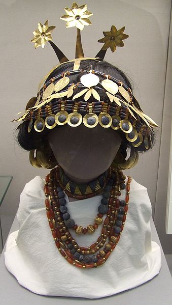
Sumerian Headgear and Necklaces British Museum. This artifact was found in the tomb of Puabi in the "Royal tombs" of Ur Most of the treasures excavated at Ur are in the British Museum and the University of Pennsylvania Museum of Archaeology and Anthropology. At the Penn Museum the exhibition "Iraq's Ancient Past", which includes many of the most famous pieces from the Royal Tombs, opened to visitors in late Spring 2011. Previously, the Penn Museum had sent many of its best pieces from Ur on tour in an exhibition called "Treasures From the Royal Tombs of Ur." It traveled to eight American museums, including those in Cleveland, Washington and Dallas, ending the tour at the Detroit Institute of Art in May 2011.
In 2009, an agreement was reached for a joint University of Pennsylvania and Iraqi team to resume archaeological work at the site of Ur.
Archaeological remains :
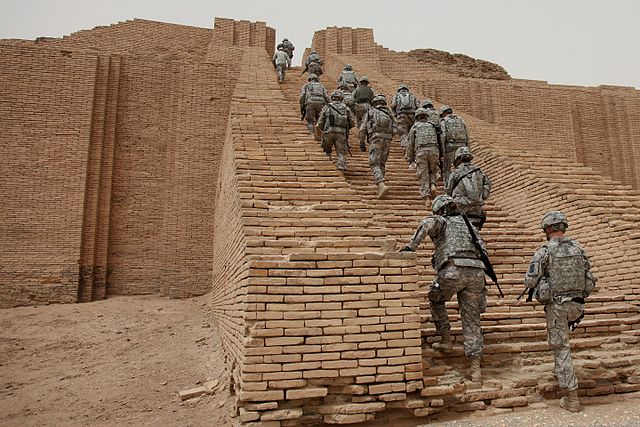
U.S. soldiers ascend the reconstructed Ziggurat of Ur in May 2010 Though some of the areas that were cleared during modern excavations have sanded over again, the Great Ziggurat is fully cleared and stands as the best-preserved and most visible landmark at the site. The famous Royal tombs, also called the Neo-Sumerian Mausolea, located about 250 metres (820 ft) south-east of the Great Ziggurat in the corner of the wall that surrounds the city, are nearly totally cleared. Parts of the tomb area appear to be in need of structural consolidation or stabilization.
There are cuneiform (Sumerian writing) on many walls, some entirely covered in script stamped into the mud-bricks. The text is sometimes difficult to read, but it covers most surfaces. Modern graffiti has also found its way to the graves, usually in the form of names made with coloured pens (sometimes they are carved). The Great Ziggurat itself has far more graffiti, mostly lightly carved into the bricks. The graves are completely empty. A small number of the tombs are accessible. Most of them have been cordoned off. The whole site is covered with pottery debris, to the extent that it is virtually impossible to set foot anywhere without stepping on some. Some have colours and paintings on them. Some of the "mountains" of broken pottery are debris that has been removed from excavations. Pottery debris and human remains form many of the walls of the royal tombs area. In May 2009, the United States Army returned the Ur site to the Iraqi authorities, who hope to develop it as a tourist destination.
Preservation :
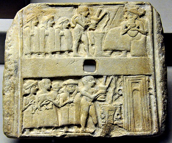
Wall plaque from Ur, 2500 BCE. British Museum Since 2009, the non-profit organization Global Heritage Fund (GHF) has been working to protect and preserve Ur against the problems of erosion, neglect, inappropriate restoration, war and conflict. GHF's stated goal for the project is to create an informed and scientifically grounded Master Plan to guide the long-term conservation and management of the site, and to serve as a model for the stewardship of other sites.
Since 2013, the institution for Development Cooperation of the Italian Ministry of Foreign Affairs DGCS and the SBAH, the State Board of Antiquities and Heritage of the Iraqi Ministry of Tourism and Antiquities, have started a cooperation project for "The Conservation and Maintenance of Archaeological site of UR". In the framework of this cooperation agreement, the executive plan, with detailed drawings, is in progress for the maintenance of the Dublamah Temple (design concluded, works starting), the Royal Tombs—Mausolea 3rd Dynasty (in progress)—and the Ziqqurat (in progress). The first updated survey in 2013 has produced a new aerial map derived by the flight of a UAV (unmanned aerial vehicle) operated in March 2014. This is the first high-resolution map, derived from more than 100 aerial photograms, with an accuracy of 20 cm or less. A preview of the ORTHO-PHOTOMAP of Archaeological Site of UR is available online.
Tal
Abu Tbeirah :
Source :
https://en.wikipedia.org/wiki/Ur |
|||||||||||||||||||||||||||||||||||||||||||
.jpg)
_but_2500_-_6000_y.o..jpg)
_(14767185992).jpg)