| LOCATION OF ARYAN HOME LAND Airyana
Vaeja's Features
Sugd / Sogdiana :
Mouru / Margiana :
Balkh / Bactria & King Vishtasp :
Balkh became the capital city of the Kayanian kings and ancient Airan, the successor state to Airyana Vaeja and the predecessor state to modern Iran.
Today, all three regions noted above claim Zarathushtra as their native son and make some claim to his legacy. The claims include the region being his birthplace, where he received his revelations, where he first propounded his religion, where he composed his message and the scriptures, and where he died. No other region makes these claims to this extent.
What this indicates is, that regardless of the veracity of the claims, there is a strong possibility that Zarathushtra travelled to these regions and that they were within travelling distance of Airyana Vaeja, Zarathushtra's birthplace. By listing these nations separately from Airyana Vaeja, the Avesta's Vendidad is probably also stating that the three lands were separate from Airyana Vaeja. Since Zoroastrian texts also tell us that Airyana Vaeja was Zarathushtra's native home, we can surmise that while Zarathushtra could have travelled to these lands spreading his message, none of them was his native home.
Airyana Vaeja's Terrain
Verses 10.13-14 of the Meher Yasht state that the Aryan land had many mountains, valleys, and pastures (pouru vastraongho) that supported cattle (gave). It was rich in waters (afento), deep lakes (jafra varayo) and wide rivers. The land, while mountainous had alpine meadows and fertile, well-watered vales.
Rivers of Airyana Vaeja: Daraja and Daitya :
Both rivers are mentioned as separate rivers in the Lesser Bundahishn (24.14 - 16, E. W. West in Sacred Books of the East Vol. 5, 1897): "14. The Daitya River is the chief of streams. 15. The Daraja river is the chief of exalted rivers, for the dwelling of the father of Zartosht was on its banks, and Zartosht was born there." We read here that Zarathushtra (Zartosht in Middle Persian) was born on the banks of the Daraja River in Airyana Vaeja (Iran Vej in Middle Persian) upon whose banks stood his father's house. The Lesser Bundahishn at 20.32 states, "The Daraja river is in Eranvej, on the bank (bar) of which was the dwelling of Pourushasp, the father of Zartosht (Zarathushtra)."
Veh Rivers :
The river called Vanguhi Daitya in Avestan is sometimes identified as the Veh in Middle Persian Pahlavi texts. In the Middle Persian Bundahishns, the Veh River is in turn is identified both as the Amu Darya / Oxus River as well as the Indus River. However, in the Bundahishn, the Daitya river itself that in Avestan passages is accompanied by the word Vanguhi is in the Bundahishn mentioned without the word Vanguhi or Veh. While the Bundahishns state that other rivers that otherwise have their own name are sometimes called Veh, the Bundahishns' Veh River which seems identical to today's Amu Darya / Oxus is the only river in the Bundahishns that is not directly associated with another name. In other words in the Bundahishns, the river is only named the Veh and we are not told if it had another accompanying of associated name.
Regarding identification of the Veh with the Oxus / Amu Darya River, the Lesser Bundahishn at 20.22 states that "the Balkh river comes out from the Aparsen likely Gk. Paropamisus (interestingly also called the Alburz in some modern maps.) at the eastern end of the Hindu Kush mountain of Bamikan (likely Bamian/Bamiyan), and flows on to the Veh river." Today, the Balkh river rises in the eastern Hindu Kush in Bamiyan province and flows north into Balkh province. Before irrigation reduced its flow, it was a tributary of the Amu Darya]. The Lesser Bundahishn at 20.22 also states that "The Teremet river flows away to the Veh river." Teremet is identified by West as Tajikistan's Termez today across the Amu Darya / Oxus from Balkh province. Termez would have been the gateway to the northern valley of Bakhdhi/Balkh, a valley that leads to Dushanbe, Tajikistan's present capital.
*[Alburz/Elburz/Alborz mountains: Today, the mountains of northern Iran are called the Elburz. Wikipedia also reports, "As recently as the 19th century, a peak in the northernmost range in the Hindu Kush system, just south of Balkh, was recorded as Mount Elburz in British army maps." The name Alborz is said to derive from the Avestan Hara Berezaiti or Hara-Berez, the Hara mountains. Hara-Barez became Har-borz and eventually Al-borz. As did the legendary rivers of Airyana have their source in the Hara-Bareza (meher Yasht 10.14), the Bundahishn continues the tradition of ascribing the source of the principal Veh rivers in the Alborz.]
Middle Persian texts and the Shahnameh tell us that the Amu Darya or Oxus river formed a border of ancient Bakhdi, and that the border between Airan (the later name form of Airyana Vaeja) and Turan was also the Amu Darya. The Amu Darya river runs from the Pamirs (where it is called the Panj) to the Aral Sea and today, to some extent, forms the border between four nations, Tajikistan, Afghanistan, Uzbekistan and Turkmenistan. A portion of the Amu Darya river runs north of present day Balkh in Afghanistan.
Regarding identification of the Veh with the Indus River, the Greater Bundahishn at 11.A.2 as translated by B. T. Anklesaria states, "The river Veh passes on in the east, goes to the land of Sind and pours into the sea in India. There they call it the river Mitran [and also call it the river Indus]." The Lesser Bundahishn translated by E. W. West, at 20.7 states, "The Mehrva River they call the Hendva River...". Hendva would be connected to Hindu. 20.9 also states, "The Veh River passes on in the east, goes through the land of Sind, and flows to the sea in Hindustan, and they call it there the Mehra River." We note that this river is called Hendva, Mehrava, Mehra, Mitran (Mithra/Mitra and Mehr are related words, the former being the older form which seems to be the trend in the Greater Bundahishn. The Lesser Bundahishn starts with the declaration at 20.1 that two rivers flow from the north - from the Alburz (Mountains) - and that the one towards the East is the Veh River.
We are therefore left with two Veh rivers, one identified with the Amu Darya (Oxus) and the other with the Mitran or Mehra (the Indus). Masudi in his Historical Encyclopaedia writes that the "Guebers (sic) i.e. Zoroastrians, felt that the Jaihun (Oxus) was connected with the Indus to form one river, the Veh." The ancients may have perceived the Veh as a mythical circumventing river, one that circumvented Airyana in the east and the west - perhaps even all the way around.
Rivers Flowing into Neighbouring Countries :
There are very few sets of rivers that meet this description and they all originate in the mountains of Afghanistan and Tajikistan radiating westward from the Pamirs. Since 1. Bakhdhi (Balkh) is a significant omission from this list, 2. Khairizem is a nation not mentioned directly in the Vendidad's list of nations and appears to be a "younger" nation than the Vendidad nations [together with Parsa (Persia) and Mada (Media) also not mentioned], and 3. the Aryan lands are called by a slightly different name than in the Vendidad, one possibility is that this Meher Yasht description was part of the younger Avesta, by time of whose writing, the original Aryan lands, Airyana Vaeja, had begun to move westward along the northern Hindu Kush slopes, towards the Kuh-e Baba, Kuh-e Hissar and Safid Kuh - the northern Afghanistan mountain region south of Balkh. To us it is not without significance that there is a Murgab River in the Pamir highlands of Tajikistan, then in the northern Afghanistan and eventually in Pars.
The larger river flowing into Mourum (Eng-Gk Margiana) is the Murgab River; the main river flowing through Haroyum (Eng-Gk Aria) is the Hari-Rud River; the main river flowing through Sughdhem/Sugd (Eng-Gk Sogdiana) is the Zerafshan River. The Kashka Darya also flows through Sughdhem. Sughdhem was likely bordered by the Amu Darya (Oxus) in the west/south-west and Syr Darya (Jaxartes) Rivers in the east/north-east. There are of course, other smaller rivers. The Pamirs together with the Hindu Kush and its western extensions including the Safeed Kuh and Siah Kuh mountains that border today's Northern Afghanistan are where these rivers originate.
The Lesser & Greater Bundahishns at LB Chapter 20 and GB Chapter 11.A respectively provide additional information. We reproduce here portions of the Bundahishn related to the rivers of Central Asia identified above via the Meher Yasht. However, the Bundahishns only assign the rivers Daraja and Daitya to ancient Iran-Vej (Airyana Vaeja). Regardless, we still see these lands the rivers flow through as part of greater Aryan nation, Iran-Shahr :
LB 13. The Daitya river is the river which comes out from Eranvej, and goes out through the hill-country; of all rivers the noxious creatures in it are most, as it says, that the Daitya river is full of noxious creatures. [Our note: it is significant that the Daitya is noted as "going through hill country".] GB 11.A.7 states "The river Daitya comes out of Eranvej and proceeds to Dutistan." We have yet to identify Dutistan.
The other rivers implied by the Meher Yasht are described by the Bundahishns as follows :
Harirud :
Rivers of Sughdhem/Sugd :
GB 11.A.14:"The river Zeshmund, on the side of Soghd (Sugd, Sogdiana), pours back into the river Khvajand." LB 20.19: "The Zishmand river, in the direction of Soghd, flows away towards (from?) the Khvejand river." These two statements are somewhat contradictory and a more critical translations of the originals is required. The river sounds like the Zerafshan. If this is so, the statement should read that the river flows away from the Khvajand (Jaxartes/Syr Darya) and into the Veh, the Amu Darya or Oxus. If not, it denotes another river, perhaps a tributary of the Khvajand.
Curiously, the LB at 20.30 states, "The Kasak river comes out through a ravine (kaf) in the province of Tus (the birthplace of Ferdowsi in Khorasan?), and they call it there the Kasp river; more- over, the river, which is there the Veh, they call the Kasak; even in Sind they call it the Kasak." Translator E. W. West feels "Sind" here is a corruption or misprint of the intended name "Seni" leading the the line reading, "even in Seni they call it the Kasak." Seni is a name mention in the Lesser Bundahishn at 15.29: "the country of Seni, that which is Kinistan/Chinistan". E. W. West further postulates that in this context "Kinistan" may refer to Samarkand the principal city of Sugd. He goes on the identify Seni as the Saini of the Farvardin Yasht at 13.143,144, one of the five lands praised in the Yasht having holy followers. There is today the River Kashka that flows from Sugd today.
Murgab. River of Marv :
Amu Darya (Oxus), Balkh and Termez Rivers :
The Lesser Bundahishn at 20.22 also states that "The Teremet river flows away to the Veh river." Teremet is identified by West as Tajikistan's Termez today across the Amu Darya/Oxus from Balkh province. Termez would have been the gateway to the northern valley of Bakhdhi/Balkh, a valley that leads to Dushanbe, Tajikistan's present capital.
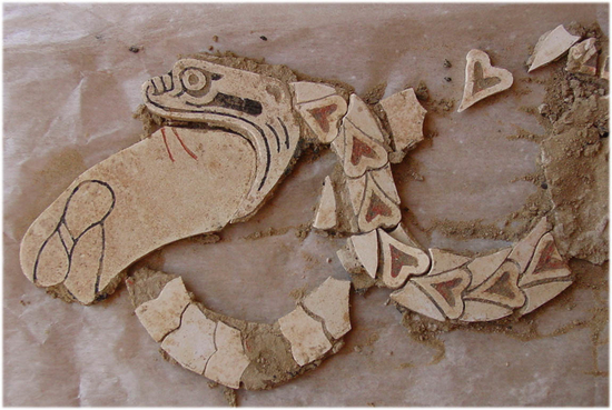
Mosaic of a snake swallowing an object from Central Asia dating to the Bronze Age (2500-1500 BCE)
Noxious Creatures in Airyana Vaeja's Rivers :
The Greater Bundahishn translated by B. T. Anklesaria at Chapter 11.A.7 & 8 states "The river Daitya comes out of Eranvej and proceeds to Dutistan. Of all the rivers, the noxious creatures abound the most in it. As one says, 'The river Daitya is full of noxious creatures'."
The Indus on its part was known to have alligators which could perhaps have been identified as a form of snake. Captain John Wood in his A Journey to the Source of the River Oxus, (London) 1872, p. 10-11 describes his encounter with a herd of alligators while travelling up the lower Insus.
Mountains - Hara Berezaiti, the Hara Mountains :
Reading the Zamyad Yasht at (19.1) we are given the impression that the Hara was one of two concentric rings of mountains, or at least ones that "lie all around". Many authors add "encircling the earth" or words to that effect to their translations, but there are no such words in the verse. The Yasht also states two thousand, two hundred and forty four peaks rose from these mountains and names several.
The Aban Yasht at 5.21 states that (King) Hushang paid homage at the "upa upabde" (sometime translated as "base" or "enclosure". Upa means "near". We read "near the environs") of the Hara.
In Mehr Yasht 10.118, we are introduced to the term "Hara Berezaiti". The modern word Alburz is said to be derived from Hara Berezaiti. Hara Berezaiti it is said in the literature became Hara-Barez (in Yashts 5.21 and 17.24) then Har-borz and eventually Al-borz. The word "hara" is said to mean "watch, guard, defence" and is derived from from the Old Iranian prefix har- meaning "to pay attention, watch over, protect". The implication is that the Hara Mountains got their name since they served as a defensive wall against invaders or plunderers. Indeed, the Greater Bundahishn at 24.24 notes that every three years, people of non-Arian nations would gather on the Alburz (Hara) mountains in order to cause harm - perhaps sweeping down into the Aryan lands from ridges and passes. The word "berezaiti" is said to stem from "berez" meaning "height", "exalted" or even "towering". It is also said to have evolved into the New Persian words "boland" meaning "tall" or "high" and "bozorg" meaning "big" or "great". With "berezaiti" as an adjective we are left with the impression that the Hara was a high protective barrier. The one mountain range that fits this description very well is the Hindu Kush. Hindu means resident of the (upper) Indus region and Kush is said to be the same as "kusht" meaning "kill". The Hindu Kush is a natural barrier between the Indus and Kabul valleys (to the south) and Wakhan valley (to the north), and by extension the Badakshan/Pamir region.
Nowadays, Alburz/Alborz/Elburz is the name of the mountains in northern Iran. Wikipedia also reports, "As recently as the 19th century, a peak in the northernmost range in the Hindu Kush system, just south of Balkh, was recorded as Mount Elburz in British army maps (i.e. the western arm of the Hindu Kush)." The same mountains are also called the Aparsen (likely Gk. Paropamisus) in the Bundahishn. We are also given to understand that the highest peak of the Caucasus is also called "Elbrus". The poet Ferdowsi's references to the Alburz in his epic, the Shahnameh, lead us to the environs of Hind, perhaps meaning the mountains of the Upper Indus, the Hindu Kush, Pamirs, Karakorum and Himalayas - the Alburz or Hara Berezaiti of old. Strabo would call the Hara Berezaiti the Taurus Mountains, a string of mountains that ran from Turkey to the boundaries of China.
The two Bundahishns, the Middle Persian or Pahlavi Zoroastrian texts, see the Alburz (Hara Berezaiti) in two ways (see Lesser Bundahishn 20.1): one the mythical mountains that encircled the earth - the primal mountain range from which all other mountain ranges arose - and two, a specific group of mountain ranges in which two rivers at east and west of the Aryan lands had their source (and according to Zadsparam at 6.21, the source of an additional "great" eighteen rivers). We see these two aspects reflected elsewhere. The Zamyad Yasht reads in a factual manner while some other passages tend to add more fantastic elements. From the Zamyad Yasht we do get the sense that other mountain ranges rise from (perhaps radiate?) from the Hara and that it could conceivably lend its name to connected mountain chains. By the time the Middle Persian Bundahishns and other texts were written, the description is almost entirely mythological as are parallel descriptions in Hindu and Buddhist texts we describe below. In mythology, the Alburz encircled the earth - a band like the Milky Way of the heavens.
As the mythical mountains that surrounded the earth, the Alburz mountains are similar to the Lokaloka of the Hindu scriptures. [Lokaloka means "world-no world" and is in Vedic Hindu mythology, a magnificent belt of mountains girdling the outermost of the seven lands (Phl. keshvar / Vedic dvipa) and seas and one which separates the visible world from the region of darkness beyond. The Lokaloka is said to be ten thousand yojanas in breadth and height. The modern equivalent of a yojan is disputed and is thought to be 6 to 15 kilometres making the mythical Lokaloka some 60,000 to 150,000 km. in circumference.]
Tera :
Ichaporia and Humbach as well as Sethna do not translate "taera" as the name of a mountain but rather as "peak". However, it does make more sense in the contexts above to read it as several or a set of peaks rather than a single peak. But that sense of a single peak rising into the heavens is now embedded in Hindu and Buddhist mythology as well. In the Zamyad Yasht, there is no mythology in the description of the mountains. They are listed quite matter-of-factly and the word "taera" appears buried in the middle of verse 19.6 in a rather obscure manner.
Mary Boyce informs us that when the Khotanese Saka became Buddhists, they referred to Mt. Sumeru of Buddhist legends as Ttaira Haraysa, the peak of Hara. Mt. Sumeru in Buddhist mythology lies at the centre of the earth and according to Anklesaria's translation of GB 5B.1, "Mount Tera is in the middle of the earth."
Principal Hara Peaks - Mount Hukaria and Daitik :
The combined manner in which the Hukar, Tera and Daitik are described in the Bundahishn has resonance with the manner in which Mount Meru, Sumeru, is described in Hindu and Buddhist texts.
Mount Meru / Sumeru :
The Wikipedia article on Jambudvip, the environs in which Mount Meru stands, identifies Jambudvipa with the Pamir region. In the Vedas, each of the four sides of Meru are made of four different precious substances: the south of lapis-lazuli, the west of ruby, the north of gold and the east of silver (or crystal). The Pamir-Badakhshan region was noted for precisely these precious substances and home to the only known lapis mines in antiquity. Further, the lapis mines were in the south of the Pamir region.
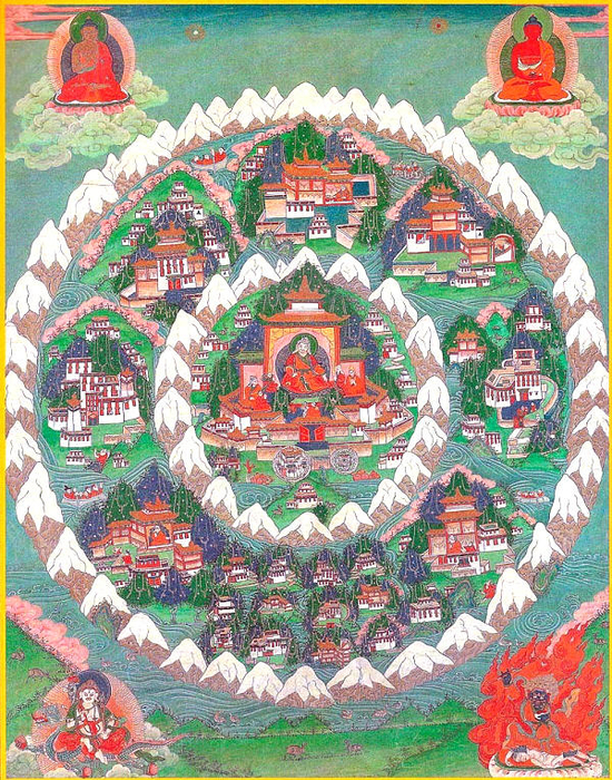
Airyana Vaeja as Paradise. Shambhala / Shangri-La :
Buddhist Tanka showing Shambhala with Mount Meru in the centre. Buddhist thangka showing Shambhala with Mount Meru & a temple in the centre. The two circular mountain ranges remind us of the description of the Hara and Zeredaza Mountains in the Avesta's Zamyad Yasht "lying all around" - the Zeredaza being the outer range. As we have noted above, Zoroastrian texts describe Airyana Vaeja as being mountainous with fertile meadows and valleys. In addition, the opening words of the Avestan Vendidad's chapter listing the sixteen nations, states that if God had not made other countries beautiful in some manner, all the world would have swarmed into Airyana Vaeja on account of its great beauty and - as mentioned elsewhere in the Avesta (see next paragraph) - because of its wise king and good government, law and order, noble people and serenity. Airyana Vaeja was a paradise on earth - a land of peace and serenity, the best place to live and raise a family.
The heavenly nature of Airyana Vaeja during the Jamshidi era reached mythic proportions in Yasht 19.33, the Zamyad Yasht. Then, the weather was neither cold nor hot, there was no untruth and envy, people were undying, water and plants never drying. All because King Jamshid ruled wisely and the people lived honestly. However, when the king lost his grace and the people lost their noble ways, Airyana Vaeja became a paradise lost.
Tibetan Buddhism's book of Kala-Chakra, the Time-Cycle, and Tibetan Buddhism's predecessor religion, Bon, built on and popularized this concept of a lost and hidden paradise on earth, now known to the world as Shangri-La.
[The founding of the Bon religion is ascribed to Tonpa Shenrab Miwoche who was born - by some estimates 18,000 years ago - in the land of Tagzig Olmo Lung Ring. Tagzig, is believed to be a form of the name Tajik. (The name Shenrab sounds Iranian as well.) The doctrine taught by Tonpa Shenrab was spread by his disciples and their student-translators to adjacent countries such as Zhang-Zhung (also Zhangzhung, Shang Shung or Xang Xung - a land north of the Himalayas, which contained Mount Kailash in today's Western Tibet), India (northern Indus valley), Kashmir, China and eventually Greater Tibet. Tonpa Shenrab is reputed to have visited present-day western Tibet once. On that visit he found the people unprepared to receive the entire body of his teachings, but he prophesied that his teachings would flourish in Tibet in the coming ages. The students of his disciples continued his mission and Tibetan Bon scriptures were translated from texts in the language of Zhang-Zhung.
[Bon claims to have spread south to the Indian subcontinent and to have influenced the development of Vedic Hinduism. Perhaps pre-Tibetan Bon was a form of the primordial Aryan religion before Zoroastrianism and Vedic Hinduism. Buddhism in turn evolved out of Vedic Hinduism (c. 400 BCE). Completing a full circle, today's Bon is so heavily influenced by Buddhism that it sounds like a Buddhist sect. Perhaps some scholars may take it upon themselves to try and isolate the precepts of the pre-Buddhism Bon.
[It may be of interest to those studying the weather change in Airyana Vaeja, that pollen and tree ring analysis indicates the Chang Tang plateau in Northern Tibet had a far more liveable environment than it has today - one that supported a primordial civilization - until the climate become colder and drier starting around 1500 BCE, a climate change that caused the population to migrate out of the northern plateau. This authors also feels that the ancient Aryan and Zoroastrian link to western Tibet is further exemplified by the common tradition of exposing the dead to birds. Also see our blog, Iranian-Aryan Connections with Western Tibet.]
At the centre of the land of Tagzig (called Shambhala in the Kalachakra) was Olmo Lungring which had at its centre, Yungdrung Gutsek, a four-sided mountain similar to Mount Meru / Sumeru (see above). The mountain is surrounded by temples, cities and parks. To the mountain's south is the Barpo Sogye palace, where Tonpa Shenrab was born. The complex of palaces, rivers and parks with Mount Yungdrung Gutseg in the centre constitutes the inner region (Nang-gling) of Olmo Lungring. The intermediate region (Bar-gling) consists of twelve cities, four of which lie in the four cardinal directions. The third region includes the outer land (mTha'-gling). These three regions are encircled by snow-capped mountains and an ocean.
The mountain Yungdrung Gutsek has nine Yungdrungs (swastikas) ascending like a staircase. It is not without significance that the swastika plays an important symbolic role in both the Bon and Vedic Hindu religions. In Bon, The nine swastikas represent the Nine Ways. The swastika (Yungdrung) itself is a symbol of permanence and indestructibility of the mind-stream, the wisdom of Bon. The full name of Bon is Yungdrung Bon meaning Everlasting Truth.
The four sides of the mountain faced the four cardinal directions. From the four corners, each of which represent four archetypal thought forms, flow four rivers :
-
From the thought form of a snow lion flows the river Narazara to
the east,
A few concepts emerge from the description of Tagzig's terrain within which lies the four-sided mountain, Yungdrung Gutsek. First, while our translation states the singular, a four-sided mountain, a mountain in all the related ancient Avestan, Vedic, and Bon texts frequently refers to a group or range of mountains with several peaks. For instance Hara Berezaiti contained two thousand, two hundred and forty four mountains peaks (see above). Next, from the four-sided Yungdrung Gutsek mountain(s) arose several rivers flowing in all the cardinal directions. In addition, this region was north of the northern Indus region. (Also see our section on the four-sided topography of the Pamirs. It is unreasonable to expect the geographic descriptions in the ancient texts to align perfectly on a modern map. The ancients used approximations formulated from the accounts of travellers over several generations and good examples of this contention are the maps drawn by classical Western authors such as Ptolemy.)
Tibetan Buddhism's Kalachakra uses the Hindu Vedic legend of Mount Meru (Avestan Hara Berezaiti) and surrounds Mount Meru with the mythic kingdom of Shambhala, a Sanskrit word meaning the land of peace. Shambhala, also spelt Shambala or Shamballa, is said to be the land of the Living Fire and Gyanganj, the home of immortal wisdom and the omniscient wise god of time (descriptions some use for Ahura Mazda, God, in Zoroastrianism). The concept, description and qualities of Shambala coincide with those for Arya Vart / Airyana Vaeja, the Aryan homeland, and help provide us with added information on its possible location.
According to the Buddhist Kalachakra, Shambhala, presently hidden to the rest of the world, is a paradise of peace, tranquility, honesty and wisdom. It is home of the primordial and highest spiritual teachings, a tantra of the cycle of time now hidden from us but one that will eventually save the world from evil. Before it adopted Buddhism, the people were followers of the Mlechha, a Yavana or western, religion, some of whom worshiped the sun. Emulating the time periods in Zoroastrian eschatology which uses a cycle of time, as well as emulating the Zoroastrian concept of a final struggle between good against evil, the Buddhist legend states that as time progresses, the world around Shambala will succumb to evil. However, three millennia after ancient Shambhala king first travelled to India and adopted Buddhism, the Shambhalians will emerge to save the world. There will be a epic battle between the righteous Shambhalians and the surrounding evil forces - a battle in which the righteous Shambhalians will prevail and defeat evil forever. As we have noted, this legend closely parallels Zoroastrian legends that presage a final struggle between the forces of good and evil in which the good, the ashavan, will prevail, transforming the world to a paradise, a heaven, on earth - the vahishtem anghuim - the transformative event being frasho-kereti.
Shambhala has both an outer temporal and an inner spiritual meaning. In the outer meaning, Shambhala is a land that is only accessible to the pure in heart. Those with impure motives will lose their way in the intervening deserts and mountains, blinded by storms. Representing the inner meaning, some thangka paintings of Shambhala depict the kingdom surrounding Mount Meru as an eight-petal lotus - a symbol for the heart chakra and an indication that Shambhala is to be found in a person's heart.
This author therefore proposes that since Shambhal, the land surrounding Mount Meru, is identified as the Vedic Arya Vart, and since the Vedic Arya Vart in turn corresponds to the Avestan Airyana Vaeja (which contains Mount Hara), that the land surrounding Shambhal, Mount Meru and Airyana Vaeja are intimately linked if not the same land. If this author's association is correct, what all four traditions, Zoroastrian, Hindu, Bon and Buddhist, have preserved, is the topography of ancient Airyana Vaeja - a land of fertile valleys and alpine meadows ringed by high snow-capped high mountains.
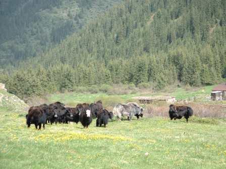
Yak grazing in the Fergana Valley adjacent to the Pamirs
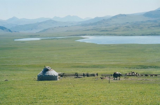
Yurt in the Pamir meadows Weather
Change in Airyana Vaeja During Jamshid's Reign :
According to Zoroastrian texts as well as Ferdowsi's Shahnameh, legendary king of Airyana Vaeja, King Jamshid, initiated the observance of Nowruz, New Year's day on the first day of spring. For King Jamshid to take this step, Airyana Vaeja must have experienced the beginning of spring and the end of winter around the spring equinox or March 21.
Further, Yasna 9.5 (similarly, Vendidad II.I.6) also states that "in the reign of Yima, there was neither cold nor heat" - a temperate climate by definition. Additional references (see * below), state that the weather in Airyana Vaeja at the outset of the Jamshedi era was equitable. However, the Vendidad and other texts also inform us that a thousand two hundred years into the Jamshedi era, Airyana Vaeja experienced severe and long winters (for a further discussion on the Jamshedi era and the weather change, see our page Aryan Prehistory)
[*References to King Jamshid/Yima: Vendidad II.I.1-20(41) and II.I.21(42)-43(140); Yasna 9.4-5; Farvardin Yasht 23.130; Aban Yasht 5.25-26; Ferdowsi's Shahnameh.]
Funerary Practices :
Location of Airyana Vaeja, the Aryan Homeland :
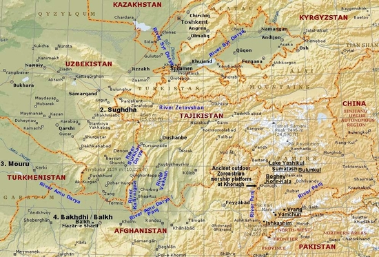
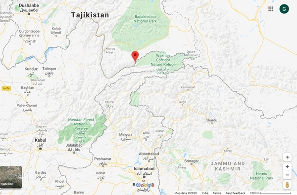
More specifically, the observations point to the strong candidacy of the Pamir-Badakhshan region (the areas neighbouring Balkh to the east and north: the upper Amu Darya basin and the Wakhan Valley of eastern Tajikistan and northern Afghanistan), the Hindu Kush to its eastern extremity south of Balkh and bordering the Murgab and Harirud valleys, the Yagnobi , Zerafshan and Fergana valleys, as well as the Alai mountain environs in Western Kyrgyzstan.
Central Asia with first Vendidad lands and possible Airyana Vaeja /Aryan homeland locale
Language Proximity of Central Asia with the Upper Indus
Supported by Archaeology :
Pamir-Badakhshan (the marked red spot is Pamir-Badakhshan) The language of the Rig Ved and the Old Avesta are so close that they are commonly thought to be dialects such as that spoken in two neighbouring provinces and that further, they emerged from a common language philologists call Proto Indo-Iranian, another name for the language of united ancient Aryans.
Panini, the author of a grammar on Classical Sanskrit which was derived from the Vedic language was a resident of Pushkalavati, Gandhar, which is now part of modern-day Charsadda District in Khyber Pakhtunkhwa, formerly known as the North-West Frontier Province of Pakistan and which included the Swat Valley now in northern Pakistan as well.
In the Swat-Chitral region, numerous archaeological sites have yielded graveyards dating between the second quarter of the second millennium BCE and the late centuries BCE, and with associated features leading the sites to be categorized as the Gandhara Grave Culture. The artefacts excavated from the sites show similarities and links with Central Asian as well as lower Indus Valley sites. The use of shell, coral and ivory were likely brought in via trade routes from the lower Indus plains and foothills.
A significant rock shelter site was excavated in the spring of 1967 near the township of Ghaligai / Ghalegay located on the east bank of the Swat River, some 12-15 km south of Mingora towards Barikot. At Ghaligai, the Swat Valley is a kilometres wide, flat, flood plain. Here, the river has many branches and frequently changes course. The valley itself is well cultivated and the crop fields slope gently down towards the river. Watercress and pumpkins are popular crops. Hills rise sharply for the valley. The eastern hills separate the Swat Valley from the Indus and Buner valleys while on the other side the western hills lie the Dir and Chitral valleys. The site has provided evidence of uninterrupted occupation for 3500 years starting from the second half of the 3rd millennium BCE. Three Carbon 14 dates of the earliest/lowest level give date from 2970 to 2930 BCE. artefacts from this level include pottery some with their inner surfaces burnished (presumably to make them water-proof from the inside). Some pottery shapes are similar to those found in Turkmenistan sites (Murgab Delta and the Kopet Dag hill base). Other artefacts found at Ghaligai as levell as Kili, Gul Hohammad, Sarai Kala, Jalilpur and Gumla show striking similarities and eveidence of trade of non-native materials primarily within the Aryan nations but also as far as the Arabian peninsula and China.
In a valley to the west of Ghaligai, archaeological finds at the Balambat site near Timergara (also spelt Timurgarh/Timargarha) and dated to 1500-600 BCE, show links with artefacts found in the lower Indus Valley site Mehrgarh as well as in Central Asian sites. [Balambat lies on the west bank of River Panjkora while Timergara lies across the river on the east bank. The name mean Timurgarh place of Timur (the Mohgul king). The Wikipedia page states that fire altars have also been found at Balambat indicating the resident to be "fire-worshippers" (sic). We are not concerned with the insulting language used in the Wikipedia page - rather, indications of the close links to an early Aryan settlement.
Aria
Aria is a candidate for the middle Aryan nation of Airan, the kingdom that features in the poet Ferdowsi's epic, the Shahnameh, and one that was formed after the Aryan nation had migrated westward. Were it not for Aria's identification with Haroyu the sixth Vendidad nation, we would be compelled to consider it as the possible location of the original Airyana Vaeja. The border between Airan and its eastern neighbour, Turan / Sugd, was the middle to lower reaches of the Amu Darya (Oxus) river. The Airan of the Shahnameh had Balkh as its capital and therefore would have included the kingdom of Bactria / Balkh / Bakhdhi as a principle kingdom. Airan was bordered by Sistan to the south.
Arrian (c.87-145 CE) in Anabasis 4.6.6 states that in antiquity, Aria was considered as particularly fertile and rich in wine. This reference by Arrian to Aria having been particularly fertile in antiquity may refer to the memory of Aria's predecessor nation, Airyana Vaeja (see above), being very fertile and a paradise on earth (rather than the present location).
Under the Sassanian dynasty (c.224 - 649 CE), the territory of Airan / Haraiva was transformed to the eastern quarter of the empire called Khurasan, Khur-a (from Khursheed meaning sun) and san (cf. stan meaning the land or place). Together, the name meant land of the (rising) sun. Greater Khorasan extended east to the Amu Darya (Oxus) River.
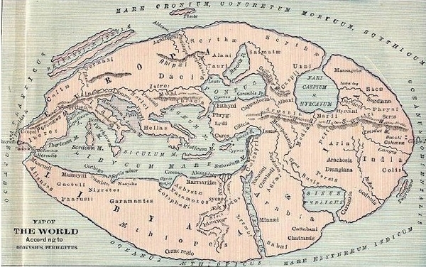
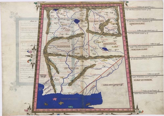
The maps below show the nations of the region from a Greek / European perspective. The borders and location are approximate at best, and often in error, as they are drawn from the descriptions in the classical texts. They nevertheless provide us with invaluable information. Note the mention of Aria, its location and prominence which is even more sticking in the map of the world according to Ptolemy.
(For a further discussion please see our page on Aria / Airan / Haroyu, and the section on Aryana in our page on Airyana Vaeja, the Aryan homeland.)
Westward
Migration of the Aryan Nation :
Source :
http://www.heritageinstitute.com/ |