| PAMIR / BADAKHSHAN REGION Pamir
/ Badakhshan Region
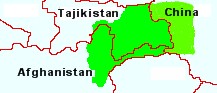
The full extent of the Badakhshan (also spelt Badakshan or Badakshon) region extends beyond the borders of Tajikistan to the east, south and south-west. To the east, Badakhshan extends into land that is today part of China. To the south and south-west, Badakhshan extends into modern-day Afghanistan.
China's acquisition of eastern Badakhshan came about through centuries of westward expansion beyond ancient Chin and the borders of Chin marked by the Great Wall of China. The division of Badakhshan between Tajikistan and Afghanistan, was a result of the Anglo-Russian agreement of 1873 that created a buffer strip between the Russian and British empires.
Pamirs & Zoroastrianism :
Candidate for the Location of Airyana Vaeja :
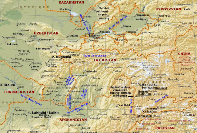
In a related page, Aryan Homeland in the Avesta, we examined references to Airyana Vaeja in the Zoroastrian scriptures, the Avesta. In that page, we listed the sixteen nations mentioned in one of the books of the Avesta, the Vendidad. Airyana Vaeja, the Aryan homeland is the first nation in that list. Its precise location is a mystery. In the map below, the second, third and fourth nations, Sughdha, Mouru and Bakhdhi, are to the left, and the Pamir-Badakhshan region is the adjacent region to the right of the map.
Central
Asia with first Vendidad lands and possible Airyana Vaeja /Aryan
homeland locale
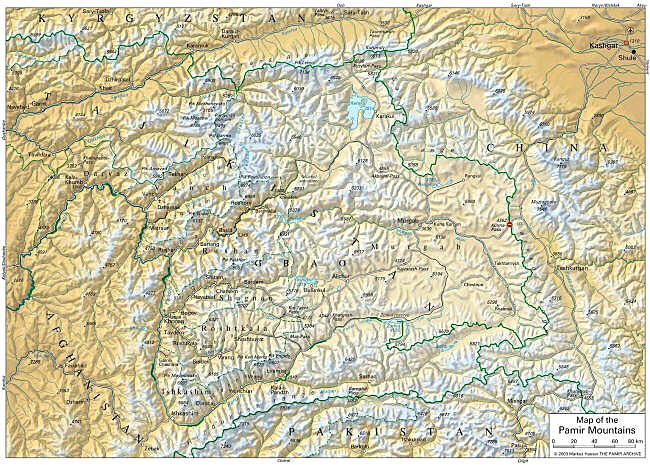
Map of the Pamir-Badakhshan region in Tajikistan, Eastern China and N. E. Afghanistan By Marcus Hauser Badakhshan (Badakshan or Badakshon) is a relatively modern (1,500 year-old) name coined by the Persian Sassanids (c.200-650 CE). Since shan / shon means place (the forerunner of stan, cf. Khorasan), Badakhshan means the place of Badak or Badakh. It is not clear who or what Badakh means. Badakh might refer to the area's precious stones.
As we have noted above, we find historic Greater Badakhshan divided between Tajikistan, Afghanistan, and China. The border between Tajikistan and Afghanistan is the Panj river where it forms the Wakhan valley. The border between Tajikistan and China is the Sarykol Range, one of the Kunlun mountain ranges.
Rather than their division by the relatively modern borders that were drawn up for political reasons, the extent of Greater Badakhshan is more accurately defined by the historic kinship of the Pamiri people and the Pamiri dialects they speak.
The Pamiri-Badakhshani people claim to be an Iranian group related to, but distinct from, the Tajiks and other Afghans. They speak dialects of the Pamiri language, an eastern Iranian language indigenous to the region. Tajiki, and the Afghan languages of Dari and Pashtu, are sister Iranian, i.e. Aryan, languages.
The extent of the Pamir-Badakhshan region as defined by the ethno-linguistic distribution of the Pamiri-Badakhshan dialects and people, is as follows (from Atlas of Languages of Intercultural Communication in the Pacific, Asia, and the Americas By Stephen Adolphe Wurm, Peter Mühlhäusler, Darrell T. Tyron, Darrell T. Tryon. International Council for Philosophy and Humanistic Studies. Pub. Walter de Gruyter, 1996) :
- In the east of the region, the Pamiri dialects of Sarikoli and Wakhi are spoken across the present Tajik-China border in the Xinjang (Xinjiang) / Kunlun Mountains. The Pamirs includes Tashkurgan and Kashgar / Kashi (presently in China) in the northeast corner (Photographs of Kashgar). The residents of Kashgar were known to have practiced Zoroastrianism and the ruins of a Zoroastrian temple can be found beside the ruins of an ancient fortress. Indeed, it is possible that some of the residents of areas in China that practice Islam today could have practiced Zoroastrianism in the past. The original Indo-Iranian inhabitants of this area have to a large extent been displaced by Turkic peoples. The Shahnameh of Ferdowsi placed Chin (China) to the east of Airan and also east of Turan (Sugd).
- In the south, the Wakhi dialect is spoken in the Wakhan / Panj valley bordered by the Hindu Kush in the south [Ivan M. Steblin-Kamenskij at Iranica, Central Asia xiii. Iranian Languages, suggests that the name Wakhan i.e. Vah-kan, is derived from Old Iranian Wahwi/Wahkshu - "good, beneficent," an ancient river name (cf. Av. Vanguhi Daitiia, the name of a river in Airiianem Vaejah]. The Wakhi dialect is also spoken in northern Pakistan. The Vendidad nation that would have bordered the Pamiri-Badakhshan region to the south would be the seventh nation of Vaekerata (Kabul).
- In the west, the region continues to include the Panj valley as it turns north and includes lands further west, that is, the present Badakhshan province in Afghanistan. That province has its capital at Feyzabab (Faizabad) that sits of the Kokcha River. In ancient times, the Pamiri-Badakhshan lands would have extended west to the fourth Vendidad nation of Bakhdhi (Balkh).
Pamir Boundaries :
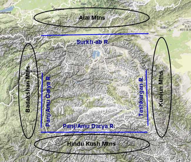
Historic Badakhshan / Pamir Boundaries - In the north, the Pamir region is bounded by a tributary of the Amu Darya (Oxus) the Surkhab / Surkhob River and Kyrgyzstan's Alai mountains. The Surkhab is renamed downstream as the Vakhsh and upstream as the Kyzylsu / Kysyl-suu River in Kyrgyzstan. Surkh-ab and Kyzyl-suu mean Red River. Reading the Vendidad's list of nations, at the northern and north-western boundary of the Pamirs, we find Sughdha (Sugd) - the land and nation that extended from the Fergana valley in the east to Samarkand in the west and beyond.
Nowadays, while all Tajiks are mainly Muslim, the Pamiri continue to display their distinctiveness by following the Ismaili sect of the Shia religion while the rest of the Tajiks are for the most part, Sunni Muslims.
During Taliban rule of Afghanistan in the 1990s and early 2000s, Badakhshan was the only Afghan province not controlled by the Pashtu dominant Taliban. Badakhshan was also the base of the group opposed to the Taliban, the Northern Alliance, the group that ultimately defeated the Taliban. Today, while the rest of Afghanistan is still in turmoil, Afghani Badakhshan is relatively peaceful.
Physical
Features
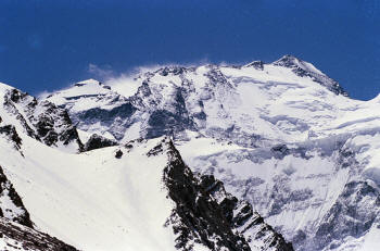
Somoni Peak. Photo: World Bank Collection at Flickr Tajiks call the Pamirs, Po-mir or Po-i-mihr, the Feet of Mitra, and also Bom-i-Dunyo, the Roof of the World. Mitra is an angel in Zoroastrianism and a pre-Zoroastrian Indo-Iranian deity, an asura.
The Pamirs are home to the tallest mountain in Tajikistan. The Somoni Peak in the northwest of the Pamirs has an elevation of 7,495 m (24,590 ft), and the average elevation of the Pamir peaks is about 3,965 m (about 13,000 ft).
The Pamirs are also called the Pamir knot since several mountain ranges radiate from the knot.
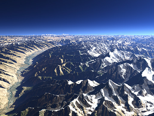
The Pamirs form a connecting link between the Tian Shan, Kunlun, Karakoram, Himalaya and Hindu Kush mountain ranges.
Terrain and Weather :
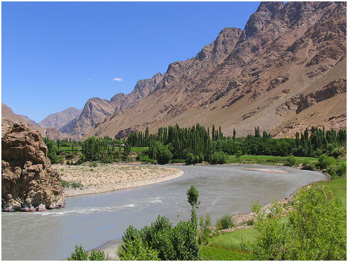
Badakhshan's terrain Badakhshan's terrain is typified by the image on the left. The Panj River runs through the valley that stretches up from the lower left corner of the photograph curving to the right. In the part that can be seen in the photograph, the Panj River marks the border between Afghanistan and Tajikistan.
The Pamirs of Tajikistan are to the left of the Wakhan Valley, while the Hindu Kush mountains (& Afghanistan's border with Pakistan) are to the right of the valley. The high mountains on the horizon are the Kunlun Mountains presently in China's Xinjiang Uygur (Turkic) Region.
The right peak (top-centre of the photograph) is the Muztagh-Ata, and the peak to Muztah-Ata's left is Kongur-Shan.
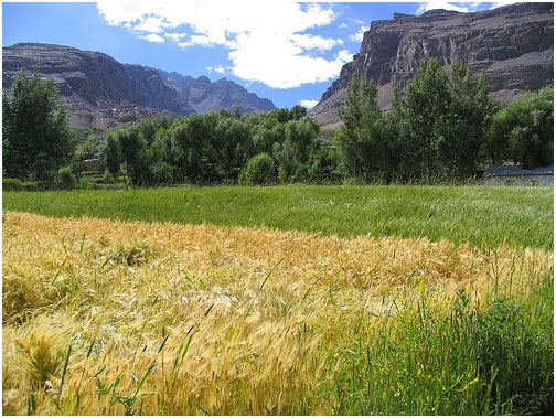
Panj River's Wakhan Valley & farms. The Panj River is called the Amu Darya (Oxus) in Afghanistan While the winters in the mountains as well as the highlands of the Murghab district of eastern Badakhshan, the Pamir Bowl, are harsh, the Pamirs are also home to temperate valleys.
While the mountains are rugged and the highlands stark, many of the valleys are fertile. The contrast in the landscape that is seen in the photograph of the Panj valley on the left, is typical.
The principle river of the Pamir-Badakhshan region is the upper reaches of the Amu Darya River, called the Panj River during its course in the south and west of the Pamir-Badakhshan region.
According to Wikipedia, the Chinese call the Pamirs 'Congling' meaning the Onion Range, a name derived from the wild onions growing in the region.
Topography
of the Boundaries :
The rivers were called daryas - rivers large enough to be considered a sea or perhaps rivers that were, in the past thought to be connected to seas. The rivers flow beyond in different directions. Mountains ranges also radiate in different directions.
The Pamirs, the Himalayas and the other mountain ranges at the north of the Indian subcontinent were formed by the subduction of the Indian subcontinent plate under the Eurasian plate. The result is that earthquakes in the Pamirs are frequent and violent. Pamiri houses are constructed to cope with earthquakes. Hot springs are numerous and the tectonic forces have created gemstones and precious metals that are buried in the mountains.
The Pamir's deposits of precious stones and metals that correspond to those described as being contained in Mount Meru, the mountain that stood at the centre of the world, in the Hindu scripture, the Vedas. Mount Meru is the equivalent of the Mount Hara Berezaiti, Airyana Vaeja's central mountain mentioned Zoroastrian scriptures, the Avesta. In the Vedas, Mount Meru is described as a four sided mountain where the four sides are made from four different precious substances: the south of lapis-lazuli, the west of ruby, the north of gold and the east of silver (or crystal).
The mountains in the south of the Pamir region do indeed contain the only lapis lazuli mines known in antiquity. The other Mount Meru precious metals and stones are also found in the region.
Passes :
Kunjarab Pass From the southeast corner to the southwest corners of the Pamir-Badakhshan region, lie the Silk Road passes that provide access to the Upper Indus region and from there - the Indus plains - Hapta Hindu (seven Indus tributaries). In the southeast corner are three passes within 100 km of each other that connect the Tamrim Basin Kashgar and Tashkurgan (today, in Xinjiang Uyghur Autonomous Region in China) to the Gojal / Hunza River valley, Gilgit and the Upper Indus valley: from east to west, the Kunjarab Pass (4,693 m./15,397 ft.) and two ancient passes, the Mintaka (4,709 m./15,450 ft.) and Kilik (4,827 m./15,837 ft.) passes. Kunjarab come from the Wakhi Pamiri word for blood valley. Ancient traders travelled 70 km south from Tashkurgan to the Mintaka River, and from there headed some 80 km west up the Mintaka valley and pass. In the central south of the Pamirs lies the Baroghil / Broghol Pass (3,798 m./12,460 ft.) through the Hindu Kush. In the southwest corner lies the Dorah Pass (4,300 m./14,000 ft.) that today connects Badakhshan in Afghanistan with Chitral in Pakistan.
Trade :
Some of the earliest trade between the Aryan nations of the Vendidad took place out of Badakhshan with its exclusive Sar-i Sang Lapis Lazuli mines on the upper reaches of the Kokcha River, a tributary of the Panj (also called Amu Darya or Oxus) exporting Lapis as far west as Mesopotamia and Egypt and as early as the 4th millennium BCE (cf. Ancient Mesopotamian Materials and Industries by Peter Roger Stuart Moorey, p. 86). Marco Polo visited the Sar-i Sang mines during his travels along the Silk Road. The area is rich in other gemstones such as rubies and emeralds and precious metals such as silver and gold that were actively traded throughout the ages (see Gem Hunter site). One of the Pamiri settlements that centred around silver mining, Bazar-Dara, is described below.
Many of the trade roads to the upper Indus and Kashmir valleys in the adjacent Indian sub-continent, including branches of the Silk Roads to the east and west, passed through the Wakhan corridor. This gave the Badakhshanis access to the Indian sub-continent. It also gave them a controlling position of the trade roads and one of the Zoroastrian era forts called the Zamr-i-Atish-Parast, or Fortress of the Fire Worshippers, at Yamchun served this function. It also formed a second line of defence for the Pamir / Badakhshan region to the north, the first line of defence being the Hindu Kush mountains.
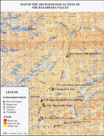
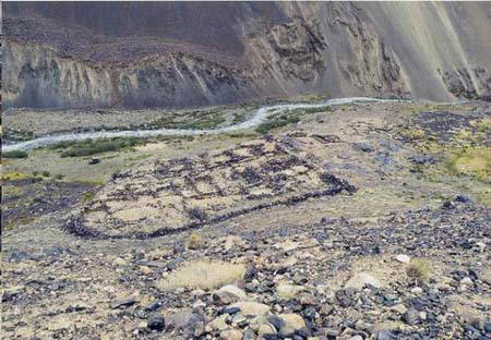
In the central Pamirs, above the banks of the river Ak-Dzhilga / Ak-Jilga, in the valley of Murghab, are the remains of remote settlements and a mining complex called Bazar-Dara and Ak-Jilga. The Badakhshan region has historically been famous from Egypt to China, the steppes to India for its gems and precious metals. Silver was mined in Bazar-Dara and traders who plied the Silk Roads came to Bazar-Dara and stayed in its caravanserai while conducting their business. The settlements and mining complex are located at a height of 4,000 m. The six sites, accessible only by foot or helicopter, are dated 10th to 11th century ACE in the middle valley, and 5th century BCE in the upper valley.
About 1,200 - 1,500 people lived in the settlement which included an administrative complex, a fire-temple, and a bath with sub-floor (kan) heating. The size fits the first level of a Jamshidi Vara (see above).
Water was obtained from small wells and skilfully designed water basins. In this region, the soil is frozen most of the year and trees cannot grow. The large building that is believed to have functioned as a medieval caravanserai, also has Vara-like features.
A webpage titled Geo-Archaeological Survey of Ancient Metallurgic Centres of the Bazar-Dara Valley contains further information on this ancient Pamiri settlement.
Bazar-Dara Caravanserai ruins Source :
http://www.heritageinstitute.com/ |