| RANGHA Transition
to the Second Phase of Zoroastrian History :
Eventually, the second phase of Zoroastrian history would be centred around Persia, a nation that is not mentioned in the Vendidad (or for that matter, anywhere in the Avesta) and which, in all likelihood, was formed after the Avestan canon was closed.
Location of Ranghaya or Rangha :
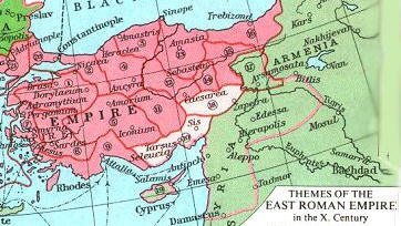
Eastern Roman Empire c. 10th cent. AC Ranghaya is identified in Middle Persian commentary as Rangha, the western lands. Middle Persian writers as well as the poet Ferdowsi called these western lands Arvastani Rum meaning Eastern Rome, since at the time of they wrote their texts, Rangha had become part of the eastern Roman empire. Around the tenth century BCE, Arvastani Rum would have included lands we know today as Turkey, northern Iraq and Syria.
The legends contained in the poet Ferdowsi's epic the Shahnameh or Book of Kings, include stories about expeditions launched west from the Iranian / Aryan land of Airan - at that time centred in Balkh - into the southern and south-west Caspian regions of Mazandaran (Avestan Varenem / Varena) and Azerbaijan (see map).
Upper Tigris / Euphrates Basin :
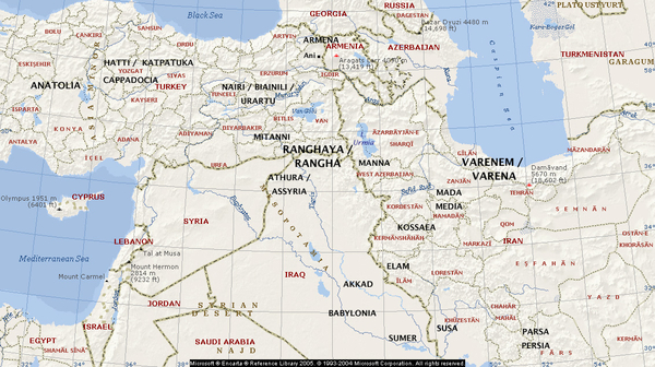
Map of the Middle East and Anatolia. Base image courtesy Microsoft Encarta
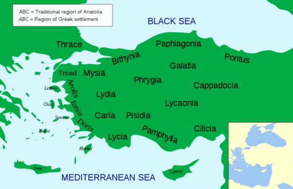
Map of the Anatolia / Asia Minor 500 - 0 BCE. Image credit Wikipedia At different points in history, the land of the Avestan Ranghaya became home to nations with various names given to them by archaeologists based on inscriptions they discovered in various sites in the region. Principally, the nation that lay at the heart of the eastern Persian empire was Cappadocia or the ancient Hittite kingdom in the land of the Hatti west of the upper Euphrates (today's Central Turkey). Ranghaya could also have included Urartu around Lake Van, and the Mitanni kingdom in the land of the Hurrians located southwest of Lake Van.
In c. 1400 BCE a Mitanni king entered into a peace treaty with the neighbouring Hittite king. The peace treaty which was recorded in rock inscriptions and carvings, invoked Indo-Iranian gods: asuras Varuna and Mitra, as well as devas Indra and the Nasatyas.
During Persian Achaemenian times (675 - 330 BCE), these lands would have been called Katpatuka (Cappadocia), parts of Armina (Armenia) around Lake Van, and Northern Athurâ (Assyria).
After the destruction of the Persian Achaemenian empire by Alexander of Macedonia and the subsequent fall of the Macedonian Seleucid rule in the mid 100s BCE, several independent Aryan-related kingdoms emerged in Asia Minor. Among these were the kingdoms of Pontus, Phrygia and Cilicia - kingdoms of special interest to students of Mithraism and its spread westward.
Pontus :
Pontus, the Mithradata kingdom, was established as an Achaemenian vassal kingdom under Mithradat(a) (Mithridates) I Ktistes within the satrapy of Katpatuka (Cappadocia). He belonged to a powerful and noble Persian family who proudly proclaimed their lineage from Cyrus and Darius I, the Great. In the 5th and 4th centuries BCE, they ruled as vassal kings over the regions of Mysia and Mariandynia on the Propontis and farther east along the south shore of the Black Sea. Even after the overthrow of the Persian Achaemenian dynasty by Alexander of Macedonia, the Mithradatid dynasty continued to rule as vassal kings of the Seleucid Macedonians.
The king best known to us because of contemporary references was Mithradat(a) / Mithridates VI Eupator (ca. 120-63 BCE). In these references, he is known primarily for his opposition to Rome against whom he fought three wars. During the first war in 89-85 BCE, Mithridates VI's armies swept through Asia Minor and Greece only to be stopped by the Romans. Eventually, the Romans under the command of Pompey, drove Mithridates VI Eupator back and eventually to his last remaining stronghold in the Crimea. There in 63 BCE he was betrayed by his son, Pharnakes, who in negotiating a settlement. Rather than face the humiliation of capture, Mithridates, tried to poison himself. When he failed to kill himself. he asked a Celtic bodyguard to kill him with his sword. On hearing of the death of his foe, Pompey ordered a full royal burial at Sinope, “because he admired his great deeds and considered him the best of the kings of his time.”
In this manner, a branch of the Persian Achaemenians managed to survive and even prosper after their defeat by Alexander.
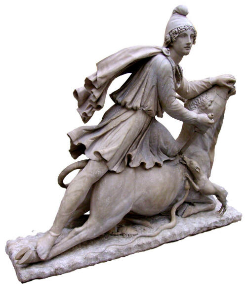
The Roman representation of Mithras wearing a Phrygian cap. Image credit British Museum Phrygia
:
Phrygia lay just to the west of Katpatuka (Cappadocia) and to the north of Cilicia. It is thought that the Phrygian kingdom began to emerge as a tribal kingdom within the Hittite empire sometime during 1200 BCE, finally becoming a kingdom in its own right upon the dissolution of the Hittite empire c. 800 BCE - until, that is, it became part of the Median empire's western boundary in 585 BCE and more completely as part Persian Achaemenian empire's western satrapy. The Persians made Paphlagonia, Mysia, and Phrygia one tax district.
Cilicia :
Cilicia is today part of Turkey's southern Mediterranean coast at its eastern-most extent and where the coast wraps around the Mediterranean and extends south towards Turkey's border with Syria (see map above). The Hittite empire would have extended into Cilicia as would have a branch of the Aryan trade roads where a port would have provided an important terminus.
Common Features of the Rangha Indo-Iranians Dynasties :
First, they all appear to have been members of Indo-Iranian (Aryan) groups who came to rule the land to which they have immigrated - lands that had native populations that accepted their rule.
Second, they brought with them a special expertise in governance and the rule of law.
Third, they respected the customs, languages and religions of the native peoples (as did the Persians when they occupied Elamite lands. Herodotus (c. 430 BCE) would say in his histories: "There is no nation which so readily adopts foreign customs as the Persians.") The Aryans went one step further than merely respecting the customs and beliefs of others - they encouraged and patronized the enhancement of native customs and beliefs. While they adopted the languages of the region for their official communication, they maintained their Indo-Iranian names. It is their names rather than the outward displays of language and religion that connect them to their Indo-Iranian heritage.
Fourth, they participated and encouraged international trade and provided the legal framework and safety for traders to traverse the trade routes that went through their territories.
Fifth, they employed the use of horse drawn light chariots in warfare.
Upper Tigris River :
The Tigris River at Diyarbakir in Turkey and the Taurus Mountain foothills. Source: Wikipedia The name Tigris is derived from the Old Persian (Achaemenian) tigra and the Middle Persian (Pahlavi) tigr. The Old Persian tigra means pointed (as in tigraxauda meaning pointed caps cf. Scythians with pointed caps mentioned in the Achaemenian inscriptions at Naqsh-e Rustam). The Middle Persian tigr similarly means sharp. The Modern Persian derivatives are tir meaning arrow and tiz meaning sharp. Another historic Persian name for the Tigris is Arvand Rud meaning Arvand River, though today, the name is used for the confluence of the Euphrates and Tigris rivers (Arabic is called Shatt al-Arab).
Eastern tributaries of the upper Tigris, the Upper (Greater) Zab, Lower Zab (Zap), and Diyala rivers, act as gateways from the Zagros Mountains to the upper and central Tigris valleys.
Upper Euphrates River :
The principle ancient cities in the upper Tigris / Euphrates valleys were Khorsabad, Nimrud and Nineveh.
Taurus Mountains :
Within the Taurus is Lake Van, the land around which was once home to the ancient nation of Urartu. In the section above we noted the possible links between the name English name Euphrates and the Akkadian purattu and Avestan peretu. The same holds true for Urartu.
Göltepe / Kestel :
To obtain tin, ancient metal workers first ground rocks and stones Into coarse powder. They then separated quartz and limestone from Iron-rich magnetite and cassiterite, a tin oxide mineral. When ground, the purplish cassiterite breaks into smaller particles than the Iron mineral, allowing it to be separated from the rest of the ore. In order to extract tin, the miners probably fired the powder between layers of charcoal in shallow covered crucibles. The charcoal heated the powder to about 950oC. Heating the ore with an arsenic compound possibly applied to the hot powder through a blowpipe could have encouraged small black, glassy beads of tin to form. Crushing and reheating this material several times would have eventually enabled the workers to get the tin to liquefy and ooze from the melt.
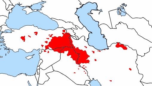
Map of the Kurdish speaking areas of the Middle East and Anatolia If we examine the distribution of Indo-Iranian peoples today, the western group is the Kurdish people. The various geographical observations we have made above regarding the possible location of Ranghaya, namely the upper Tigris and Euphrates basin and their tributaries, coincides with the the distribution of the western Kurdish speaking peoples today. This area is shaded red in the map to the right, land we will call Greater Kurdistan - a land that is today divided between Iran, Iraq, Turkey and Syria.
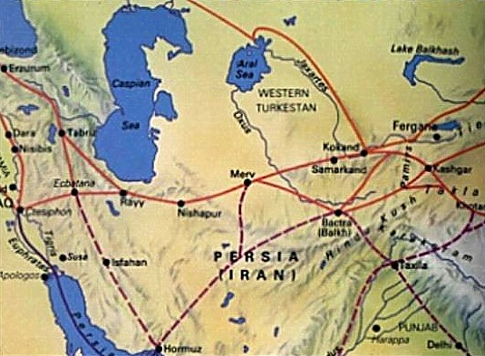
Historic Trade Route Through Iran. The Silk Road Ranghaya was located along the Aryan trade roads (Silk Roads) - as were all the other Aryan nations. Sitting across the western trade roads, Ranghaya would have been a hub for trade roads radiating west towards Anatolia and Europe, south-west towards Egypt, and south towards Babylonia, Sumer, the Persian Gulf and Arabia.
Plying the trade roads would have given Aryans access and familiarity with the lands and peoples along the trade roads. Maintaining safety through law and order would have been an essential ingredient for supporting trade, and the Aryans skills in trade and governance could have made them natural rulers even in lands in which they were a cultural minority.
Established Aryan trading colonies could have become destinations for other Aryan migrants. The Zoroastrian Aryans would have continued to settle along the trade roads even after the Avestan canon was closed.
Source :
http://www.heritageinstitute.com/ |
||||||||||||||||||||