PAMIR
MOUNTAINS
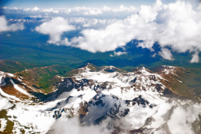
Pamir Mountains from an airplane, June 2008
Highest point
Peak : Kongur Tagh
Elevation : 7,649 m (25,095 ft)
Coordinates : 38°35'39 N 75°18'48 E
Geography
:
Countries : Tajikistan, Kyrgyzstan, Afghanistan
and China
Regions : Gorno-Badakhshan, Osh Region, Wakhan and Xinjiang
Range coordinates : 38.5° N 73.5° E
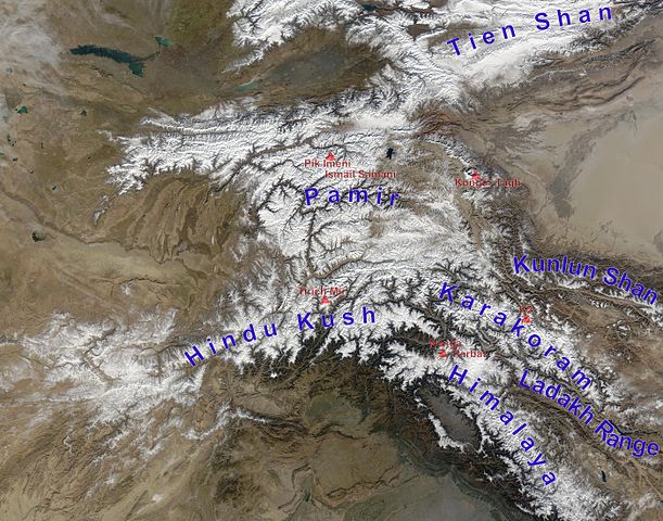
The
Pamir Mountains are a mountain range between Central Asia, South
Asia, and East Asia, at the junction of the Himalayas with the Tian
Shan, Karakoram, Kunlun, Hindu Kush, and Hindu Raj ranges. They
are among the world's highest mountains.
The
Pamir Mountains lie mostly in the Gorno-Badakhshan Province of Tajikistan.
To the north, they join the Tian Shan mountains along the Alay Valley
of Kyrgyzstan. To the south, they border the Hindu Kush mountains
along Afghanistan's Wakhan Corridor. To the east, they extend to
the range that includes China's Kongur Tagh, in the "Eastern
Pamirs", separated by the Yarkand valley from the Kunlun Mountains.
Name
and etymology :
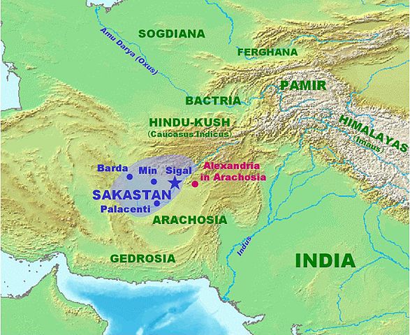
Pamir
Mountains on map showing Sakastan about 100 BC
Since Victorian times, they have been known as the "Roof of
the World", presumably a translation from Persian.
Names
:
In other languages they are called: Pashto: Pamir Ghroona; Kyrgyz:
Pamir Tooloru, Romanized: Rešte Kuhhâ-ye Pâmir;
Rishta Köhhoyi Pomir; Uyghur: Pamir Ëzgizliki, Sanskrit:
Sumeru; Urdu: Pamir Kuhestan; Traditional Chinese: pinyin: Congling;
Wade–Giles: Ts'ung-ling or "Onion Range" (after
the wild onions growing in the region). The name "Pamir"
is used more commonly in Modern Chinese and loaned as simplified
Traditional Chinese: pinyin: Pàmi'er.
"A
pamir" :
According to Middleton and Thomas, "pamir" is a geological
term. A pamir is a flat plateau or U-shaped valley surrounded by
mountains. It forms when a glacier or ice field melts leaving a
rocky plain. A pamir lasts until erosion forms soil and cuts down
normal valleys. This type of terrain is found in the east and north
of the Wakhan, and the east and south of Gorno-Badakhshan, as opposed
to the valleys and gorges of the west. Pamirs are used for summer
pasture.
The
Great Pamir is around Lake Zorkul. The Little Pamir is east of this
in the far east of Wakhan. The Taghdumbash Pamir is between Tashkurgan
and the Wakhan west of the Karakoram Highway. The Alichur Pamir
is around Yashil Kul on the Gunt River. The Sarez Pamir is around
the town of Murghab, Tajikistan. The Khargush Pamir is south of
Lake Karakul. There are several others.
The
Pamir River is in the south-west of the Pamirs.
Geography
:
Slopes
of Pamir Mountains on the Chinese side and Muztagh Ata
Mountain :
The three highest mountains in the Pamirs core are Ismoil Somoni
Peak (known from 1932 to 1962 as Stalin Peak, and from 1962 to 1998
as Communism Peak), 7,495 m (24,590 ft); Ibn Sina Peak (still unofficially
known as Lenin Peak), 7,134 m (23,406 ft); and Peak Korzhenevskaya
(Russian: Pik Korzhenevskoi), 7,105 m (23,310 ft). In the Eastern
Pamirs, China's Kongur Tagh is the highest at 7,649 m (25,095 ft).
Among
the significant peaks of the Pamir Mountains are the following :
Kongur (Kungur
Tagh) |
7,649 |
(38.593428°
N 75.312560° E) |
Kongur
Jiubie (Kungur Tjube Tagh) |
7,530 |
(38.615833°
N 75.195833° E) |
Muztagh
Ata |
7,509 |
(38.275855°
N 75.1161° E) |
Ismoil
Somoni Peak (formerly Communism Peak, Stalin
Peak) |
7,495 |
(38.943422°
N 72.015803° E) |
Lenin
Peak (new name: Abu Ali Ibn Sino Peak;
formerly Kaufmann Peak) |
7,134 |
(39.343724°
N 72.877536° E) |
Peak
Korzhenevskaya |
7,105 |
(39.057317°
N 72.00983° E) |
Independence
Peak (also Qullai Istiqlol, formerly Revolution
Peak, Dreispitz) |
6,940 |
(38.51°
N 72.354167° E) |
Russia
Peak |
6,875 |
(38.896°
N 72.029° E) |
Moscow
Peak |
6,785 |
(38.948563°
N 71.8344° E) |
Karl
Marx Peak |
6,726 |
(37.1625°
N 72.481667° E) |
Gora
Kurumdy |
6,614 |
(39.455812°
N 73.566978° E) |
Mount
Garmo |
6,595 |
(38.810955°
N 72.072344° E) |
Engels
Peak |
6,510 |
(37.171671°
N 72.522898° E) |
Koh-e
Pamir |
6,320 |
(37.15°
N 73.21° E) |
Peak
of the Soviet Officers |
6,233 |
(38.424°
N 73.302° E) |
Mayakovskiy
Peak |
6,095 |
(37.021092°
N 71.715138° E) |
Patkhor
Peak |
6,083 |
(37.889167°
N 72.189167° E) |
Leipzig
Peak |
5,725 |
(39.348°
N 72.477° E) |
Pik
Skalisty |
5,707 |
(37.6005°
N 72.227° E) |
Kysyldangi
Peak |
5,704 |
(37.4006°
N 72.8435° E) |
| Kongur (Kungur
Tagh) |
Kongur
Shan |
China |
| Kongur
Jiubie (Kungur Tjube Tagh) |
Kongur
Shan |
China |
| Muztagh
Ata |
Muztagh
Ata Massif |
China |
| Ismoil
Somoni Peak (formerly Communism Peak, Stalin
Peak) |
Academy
of Sciences Range |
Tajikistan |
| Lenin
Peak (new name: Abu Ali Ibn Sino Peak;
formerly Kaufmann Peak) |
Trans-Alay
Range |
Tajikistan,
Kyrgyzstan |
| Peak
Korzhenevskaya |
Academy
of Sciences Range |
Tajikistan |
| Independence
Peak (also Qullai Istiqlol, formerly Revolution
Peak, Dreispitz) |
Yazgulem
Range |
Tajikistan |
| Russia
Peak |
Academy
of Sciences Range |
Tajikistan |
| Moscow
Peak |
Peter
I Range |
Tajikistan |
| Karl
Marx Peak |
Shakhdara
Range |
Tajikistan |
| Gora
Kurumdy |
Trans-Alay
Range |
Tajikistan,
Kyrgyzstan |
| Mount
Garmo |
Academy
of Sciences Range |
Tajikistan |
| Engels
Peak |
Shakhdara
Range |
Tajikistan |
| Koh-e
Pamir |
Wachan
Range |
Afghanistan |
| Peak
of the Soviet Officers |
Muskol
Range |
Tajikistan |
| Mayakovskiy
Peak |
Shakhdara
Range |
Tajikistan |
| Patkhor
Peak |
Rushan
Range |
Tajikistan |
| Leipzig
Peak |
Trans-Alay
Range |
Tajikistan,
Kyrgyzstan |
| Pik Skalisty |
Schugnan
Range |
Tajikistan |
| Kysyldangi
Peak |
Southern
Alitschur Range |
Tajikistan |
Remark:
The summits of the Kongur and Muztagata Group are in some sources
counted as part of the Kunlun, which would make Pik Ismoil Somoni
the highest summit of the Pamir.
Glaciers
:
There are many glaciers in the Pamir Mountains, including the 77
km (48 mi) long Fedchenko Glacier, the longest in the former USSR
and the longest glacier outside the polar regions. Approximately
12,500 km2 (ca. 10%) of the Pamirs are glaciated. Glaciers in the
Southern Pamirs are retreating rapidly. Ten percent of annual runoff
is supposed to originate from retreating glaciers in the Southern
Pamirs. In the North-Western Pamirs, glaciers have almost stable
mass balances.
Climate
:
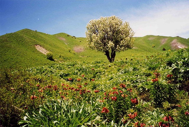
Part
of the Pamir Mountain range in springtime
Covered in snow throughout the year, the Pamirs have long and bitterly
cold winters, and short, cool summers. Annual precipitation is about
130 mm (5 in), which supports grasslands but few trees.
Paleoclimatology
during the Ice Age :
The East-Pamir, in the centre of which the massifs of Mustagh Ata
(7620 m) and Kongur Tagh (Qungur Shan, 7578, 7628 or 7830 m) are
situated, shows from the western margin of the Tarim Basin an east–west
extension of c. 200 km. Its north–south extension from King
Ata Tagh up to the northwest Kunlun foothills amounts to c.170 km.
Whilst the up to 21 km long current valley glaciers are restricted
to mountain massifs exceeding 5600 m in height, during the last
glacial period the glacier ice covered the high plateau with its
set-up highland relief, continuing west of Mustagh Ata and Kongur.
From this glacier area an outlet glacier has flowed down to the
north-east through the Gez valley up to c.1850 m asl (meters above
sea level) and thus as far as to the margin of the Tarim basin.
This outlet glacier received inflow from the Kaiayayilak glacier
from the Kongur north flank. From the north-adjacent Kara Bak Tor
(Chakragil, c. 6800 or 6694 m) massif, the Oytag valley glacier
in the same exposition flowed also down up to c. 1850 m asl. At
glacial times the glacier snowline (ELA[A]) as altitude limit between
glacier nourishing area and ablation zone, was about 820 to 1250
metres lower than it is today. Under the condition of comparable
proportions of precipitation there results from this a glacial depression
of temperature of at least 5 to 7.5 °C.
Economy
:
Coal is mined in the west, though sheep herding in upper meadowlands
is the primary source of income for the region.
Exploration
:
This section is based on the book by R. Middleton and H. Thomas
.jpg)
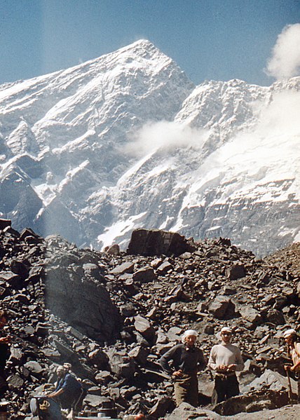
Expedition
in 1982 to Tartu Ülikool 350 Peak, which was considered to
be the highest unreached peak in the territory of former Soviet
Union at the time
The lapis lazuli found in Egyptian tombs is thought to come from
the Pamir area in Badakhshan province of Afghanistan. About 138
BC Zhang Qian reached the Fergana Valley northwest of the Pamirs.
Ptolemy vaguely describes a trade route through the area. From about
600 AD, Buddhist pilgrims travelled on both sides of the Pamirs
to reach India from China. In 747 a Tang army was on the Wakhan
River. There are various Arab and Chinese reports. Marco Polo may
have travelled along the Panj River. In 1602 Bento de Goes travelled
from Kabul to Yarkand and left a meager report on the Pamirs. In
1838 Lieutenant John Wood reached the headwaters of the Pamir River.
From about 1868 to 1880, a number of Indians in the British service
secretly explored the Panj area. In 1873 the British and Russians
agreed to an Afghan frontier along the Panj River. From 1871 to
around 1893 several Russian military-scientific expeditions mapped
out most of the Pamirs (Alexei Pavlovich Fedchenko, Nikolai Severtzov,
Captain Putyata and others. Later came Nikolai Korzhenevskiy). Several
local groups asked for Russian protection from Afghan raiders. The
Russians were followed by a number of non-Russians including Ney
Elias, George Littledale, the Earl of Dunmore, Wilhelm Filchner
and Lord Curzon who was probably the first to reach the Wakhan source
of the Oxus River. In 1891 the Russians informed Francis Younghusband
that he was on their territory and later escorted a Lieutenant Davidson
out of the area ('Pamir Incident'). In 1892 a battalion of Russians
under Mikhail Ionov entered the area and camped near the present
Murghab. In 1893 they built a proper fort there (Pamirskiy Post).
In 1895 their base was moved to Khorog facing the Afghans.
In
1928 the last blank areas around the Fedchenko Glacier were mapped
out by a German-Soviet expedition under Willi Rickmer Rickmers.
Pamir Mountains from a NASA satellite image, April 2012
Discoveries :
In the early 1980s, a deposit of gemstone-quality clinohumite was
discovered in the Pamir Mountains. It was the only such deposit
known until the discovery of gem-quality material in the Taymyr
region of Siberia, in 2000.
Transport
:
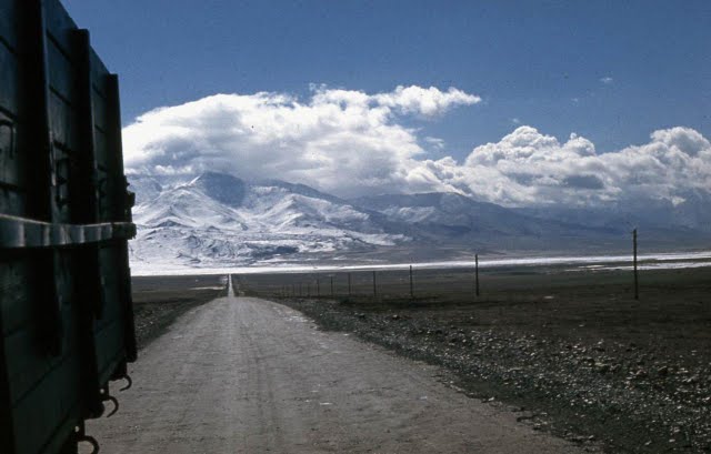
M41
highway
The Pamir Highway, the world's second highest international road,
runs from Dushanbe in Tajikistan to Osh in Kyrgyzstan through the
Gorno-Badakhshan Autonomous Province, and is the isolated region's
main supply route. The Great Silk Road crossed a number of Pamir
Mountain ranges.
Tourism
:
In December 2009, the New York Times featured articles on the possibilities
for tourism in the Pamir area of Tajikistan. 2013 proved to be the
most successful year ever for tourism in the region and tourism
development continues to be the fastest growing economic sector.
The META (Murghab Ecotourism Association) website (www.meta.tj)
provides an excellent repository of tourism related resources for
the Eastern Pamir region.
Ismoil
Somoni Peak (then known as Peak Communism) taken in 1989
Strategic position :
Climbers
near "Peak Communism" in 1978
Historically, the Pamir Mountains were considered a strategic trade
route between Kashgar and Kokand on the Northern Silk Road, a prehistoric
trackway, and have been subject to numerous territorial conquests.
The Northern Silk Road (about 2,600 km (1,616 mi) in length) connected
the ancient Chinese capital of Xi'an over the Pamir Mountains towards
the west to emerge in Kashgar before linking to ancient Parthia.
In the 20th century, they have been the setting for Tajikistan Civil
War, border disputes between China and Soviet Union, establishment
of US, Russian, and Indian military bases, and renewed interest
in trade development and resource exploration. China has since resolved
most of those disputes with Central Asian countries.
Religion
:
Some researchers identify the Pamirs with the Mount Meru or Sumeru.
The Mount Meru is the sacred five-peaked mountain of Buddhist, Jain,
and Hindu cosmology and is considered to be the center of all the
physical, metaphysical and spiritual universes.
Source
:
https://en.wikipedia.org/
wiki/Pamir_Mountains