| TIAN SHAN
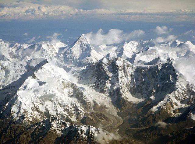
The Tian Shan range on the border between China and Kyrgyzstan with Khan Tengri (7,010 m) visible at center Highest
point : Peak Jengish Chokusu
The Tian Shan, also known as the Tengri Tagh or Tengir-Too, meaning the Mountains of Heaven or the Heavenly Mountain, is a large system of mountain ranges located in Central Asia. The highest peak in the Tian Shan is Jengish Chokusu, at 7,439 metres (24,406 ft) high. Its lowest point is the Turpan Depression, which is 154 m (505 ft) below sea level.
One of the earliest historical references to these mountains may be related to the Xiongnu word Qilian (simplified Pinyin: Qí lián) – according to Tang commentator Yan Shigu, Qilian is the Xiongnu word for sky or heaven. Sima Qian in the Records of the Grand Historian mentioned Qilian in relation to the homeland of the Yuezhi and the term is believed to refer to the Tian Shan rather than the Qilian Mountains 1,500 kilometres (930 mi) further east now known by this name. The Tannu-Ola mountains in Tuva has the same meaning in its name ("heaven/celestial mountains" or "god/spirit mountains"). The name in Chinese, Tian Shan, is most likely a direct translation of the traditional Kyrgyz name for the mountains, Teñir Too. The Tian Shan is sacred in Tengrism, and its second-highest peak is known as Khan Tengri which may be translated as "Lord of the Spirits".
Geography
:
In Western cartography as noted by the National Geographic Society, the eastern end of the Tian Shan is usually understood to be east of Ürümqi, with the range to the east of that city known as the Bogda Shan as part of the Tian Shan. Chinese cartography from the Han Dynasty to the present agrees, with the Tian Shan including the Bogda Shan and Barkol ranges.
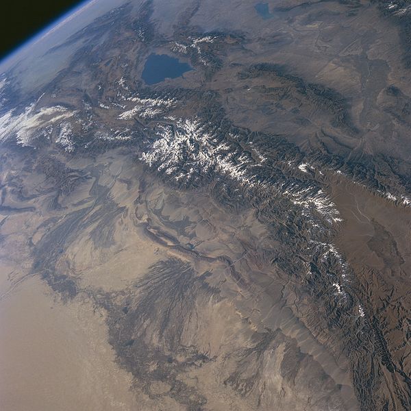
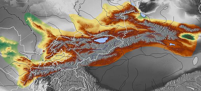
Tian Shan Mountains from space, October 1997, with Issyk-Kul Lake in Kyrgyzstan at the northern end The Tian Shan are a part of the Himalayan orogenic belt, which was formed by the collision of the Indian and Eurasian plates in the Cenozoic era. They are one of the longest mountain ranges in Central Asia and stretch some 2,900 kilometres (1,800 mi) eastward from Tashkent in Uzbekistan.
The highest peak in the Tian Shan is Jengish Chokusu (also called Victory Peak) on the border of China. At 7,439 metres (24,406 ft) high, it is the highest point in Kyrgyzstan. The Tian Shan's second highest peak, Khan Tengri (Lord of the Spirits), straddles the Kazakhstan-Kyrgyzstan border and at 7,010 metres (23,000 ft) is the highest point of Kazakhstan. Mountaineers class these as the two most northerly peaks over 7,000 metres (23,000 ft) in the world.
The Torugart Pass, at 3,752 metres (12,310 ft), is located at the border between Kyrgyzstan and China's Xinjiang province. The forested Alatau ranges, which are at a lower altitude in the northern part of the Tian Shan, are inhabited by pastoral tribes that speak Turkic languages.
The Tian Shan are separated from the Tibetan Plateau by the Taklimakan Desert and the Tarim Basin to the south.
The major rivers rising in the Tian Shan are the Syr Darya, the Ili River and the Tarim River. The Aksu Canyon is a notable feature in the northwestern Tian Shan.
Continuous permafrost is typically found in the Tian Shan starting at the elevation of about 3,500-3,700 m above the sea level. Discontinuous alpine permafrost usually occurs down to 2,700-3,300 m, but in certain locations, due to the peculiarity of the aspect and the microclimate, it can be found at elevations as low as 2,000 m.
One of the first Europeans to visit and the first to describe the Tian Shan in detail was the Russian explorer Peter Semenov, who did so in the 1850s.
Glaciers in the Tian Shan Mountains have been rapidly shrinking and have lost 27%, or 5.4 billion tons annually, of its ice mass since 1961 compared to an average of 7% worldwide. It is estimated that by 2050 half of the remaining glaciers will have melted.
Ranges
:
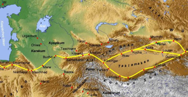
Tian Shan with the ancient silk road In China the Tian Shan starts north of Kumul City (Hami) with the U-shaped Barkol Mountains, from about 600 to 400 kilometres (370 to 250 mi) east of Ürümqi. Then the Bogda Shan (god mountains) run from 350 to 40 kilometres (217 to 25 mi) east of Ürümqi. Then there is a low area between Ürümqi and the Turfan Depression. The Borohoro Mountains start just south of Ürümqi and run west-northwest 450 kilometres (280 mi) separating Dzungaria from the Ili River basin. Their north end abuts on the 200 kilometres (120 mi) Dzungarian Alatau which runs east northeast along Sino-Kazakh border. They start 50 kilometres (31 mi) east of Taldykorgan in Kazakhstan and end at the Dzungarian Gate. The Dzungarian Alatau in the north, the Borohoro Mountains in the middle and the Ketmen Range in the south make a reversed Z or S, the northeast enclosing part of Dzungaria and the southwest enclosing the upper Ili valley.
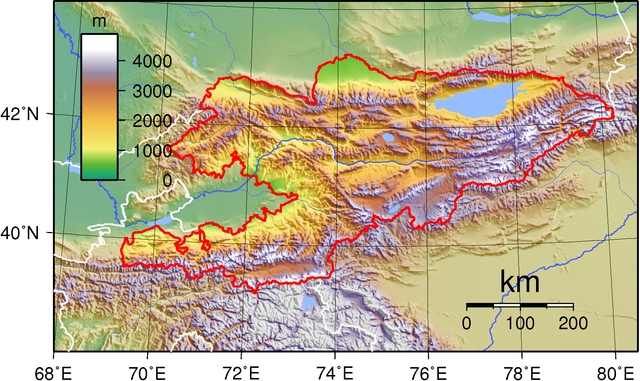
Kyrgyzstan (borders marked in red) The indentation on the west is the Fergana Valley
Map of Tian Shan
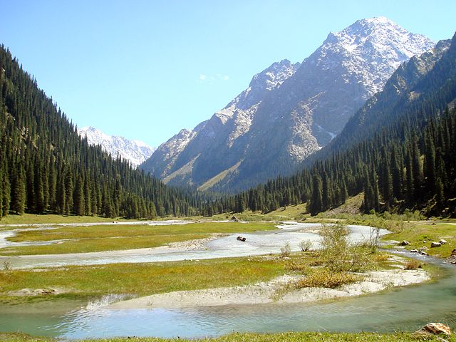
In the Karakol valley (Issyk-Kul Region, Kyrgyzstan)
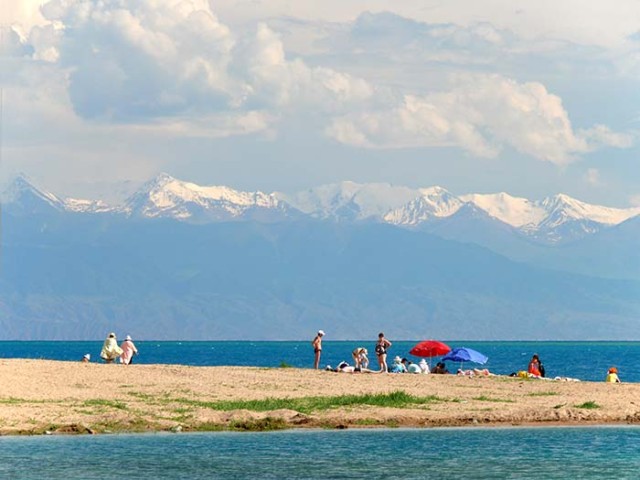
Snow-capped peaks of the Tian Shan seen from an Issyk Kul Lake beach In Kyrgyzstan the mainline of the Tian Shan continues as Narat Range from the base of the Borohoros west 570 kilometres (350 mi) to the point where China, Kazakhstan, and Kyrgyzstan meet. Here is the highest part of the range – the Central Tian Shan, with Peak Pobeda (Kakshaal Too range) and Khan Tengri. West of this, the Tian Shan split into an 'eye', with Issyk Kul Lake in its center. The south side of the lake is the Terskey Alatau and the north side the Kyungey Ala-Too (shady and sunny Ala-Too). North of the Kyungey Ala-Too and parallel to it is the Trans-Ili Alatau in Kazakhstan just south of Almaty. West of the eye, the range continues 400 kilometres (250 mi) as the Kyrgyz Ala-Too, separating Chui Province from Naryn Oblast and then Kazakhstan from the Talas Province. This oblast is the upper valley of the Talas River, the south side of which is the 200 kilometres (120 mi) Talas Ala-Too Range ('Ala-too' is a Kirgiz spelling of Alatau). At the east end of the Talas Alatau the Suusamyr Too range runs southeast enclosing the Suusamyr Valley or plateau.
As for the area south of the Fergana Valley there is a 800 kilometres (500 mi) group of mountains that curves west-southwest from south of Issyk Kul Lake separating the Tarim Basin from the Fergana Valley. The Fergana Range runs northeast towards the Talas Ala-Too and separates the upper Naryn basin from Fergana proper. The southern side of these mountains merge into the Pamirs in Tajikistan (Alay Mountains and Trans-Alay Range). West of this is the Turkestan Range, which continues almost to Samarkand.
Ice
Age :
In the same way, strong glaciation was in excess of 50 km wide in the high mountain area of the Kungey Alatau, connecting north of Issyk Kul and stretching as far as the mountain foreland near Alma Ata. The Kungey Alatau is 230 km long. Down from the Kungey Alatau the glacial glaciers also calved into the Issyk Kul lake. The Chon-Kemin valley was glaciated up to its inflow into the Chu valley. From the west-elongation of the Kungey Alatau—that is the Kirgizskiy Alatau range (42°25' N / 74–75° E)—the glacial glaciers flowed down as far as into the mountain foreland down to 900 m asl (close to the town Bishkek). Among others the Ak-Sai valley glacier has developed there a mountain foreland glacier.
Altogether the glacial Tian Shan glaciation occupied an area of c. 118,000 square kilometres (46,000 sq mi). The glacier snowline (ELA) between the glacier feeding area and melting zone was about 1200m lower during the last ice age than it is today. Under the condition of a comparable precipitation ratio, there would result from this a depression of the average annual temperature of 7.2 to 8.4 °C for the Last Glacial Maximum compared with today.
Ecology :
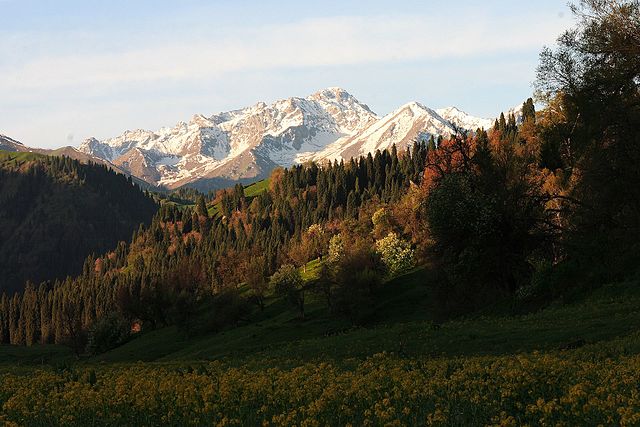
Koldeneng Valley in Ili Prefecture The Tian Shan holds important forests of Schrenk's Spruce (Picea schrenkiana) at altitudes of over 2,000 metres (6,600 ft); the lower slopes have unique natural forests of wild walnuts and apples.
The Tian Shan in its immediate geological past was kept from glaciation due to the "protecting" warm influence of the Indian Ocean monsoon climate. This defined its ecological features which could sustain its distinctive of the ecosphere. The mountains were subjected to constant geological changes with constantly evolving drainage systems which affected the patterns of vegetation, as well as exposing fertile soil for newly emerging seedlings to thrive in.
Ancestors of important crop vegetation were established and thrived in the area, among them: apricots (Prunus armeniaca), pears (Pyrus spp.), pomegranates (Punica granatum), figs (Ficus), cherries (Prunus avium) and mulberries (Morus). The Tian Shan region also included important animals like bear, deer and wild boar, which helped to spread seeds and expand the ecological diversity.
Among the vegetation colonizing the Tian Shan came, likely via birds from the east, the ancestors of what we know as the "sweet" apple. The fruit probably then looked like a tiny, long-stalked, bitter apple something like Malus baccata, the Siberian crab. The pips may have been carried in a bird's crop or clotted onto feet or feathers.
What natural features of the unique Tian Shan might have contributed to this rigorous selection program? Time is, as we have seen, not a problem. The turnover of individual trees is likewise conducive to the rapid evolution of a tree species, as is the fact that sweet apples are now, at least for all practical purposes, self-incompatible—that is, they cannot pollinate themselves. Therefore each apple tree within the forest and even each pip, usually five, within each individual fruit will be different. There are many apples on a mature tree, so natural selection has a rich and diverse population upon which to work. Birds, of course, eat all manner of fruit. But most birds eat seeds—a dietary feature not conducive either to the selection or spread of a fruit tree. Sweet apples are often eviscerated by birds, but the seeds are frequently left in the empty shell of the pome. The reason is that apple (and pear and quince) seeds are rich in cyanoglycosides, which are highly repellent, particularly to birds... Moreover, the placenta of the apple fruit, the womb, contains inhibitory substances that prevent the germination of the apple seed in situ. This is a commonly observed phenomenon in fruits as Michael Evenari showed in 1949. So what then does, or did, distribute the original apple seed The bear...
— Barrie E. Juniper
Religion
:
World
Heritage Site :
Source :
https://en.wikipedia.org/ |