| KUTCH
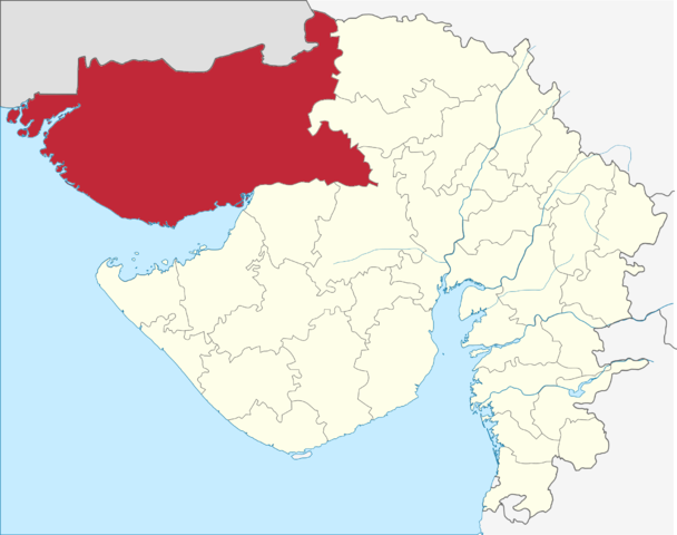
Location of Kutch district in Gujarat Kutch is a district of Gujarat state in western India, with its headquarters (capital) at Bhuj. Covering an area of 45,674 km², it is the largest district of India. The population of Kutch is about 2,092,371. It has 10 Talukas, 939 villages and 6 Municipalities. The Kutch district is home to the Kutchi people who speak the Kutchi language.
Kutch literally means something which intermittently becomes wet and dry; a large part of this district is known as Rann of Kutch which is shallow wetland which submerges in water during the rainy season and becomes dry during other seasons. The same word is also used in Sanskrit origin for a tortoise. The Rann is known for its marshy salt flats which become snow white after the shallow water dries up each season before the monsoon rains.
The district is also known for ecologically important Banni grasslands with their seasonal marshy wetlands which form the outer belt of the Rann of Kutch.
Kutch District is surrounded by the Gulf of Kutch and the Arabian Sea in south and west, while the northern and eastern parts are surrounded by the Great and Little Rann (seasonal wetlands) of Kutch. When there were not many dams built on its rivers, the Rann of Kutch remained wetlands for a large part of the year. Even today, the region remains wet for a significant part of year.
History :
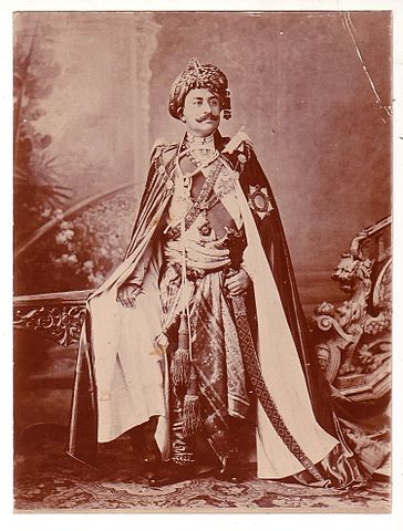
Maharao Khengarji III of Cutch - circa 1900 The history of Kutch can be traced back to prehistoric times. There are several sites related to the Indus valley civilization in the region, and it is mentioned in Hindu mythology. In historic times, Kutch is mentioned in Greek writings during Alexander. It was ruled by Menander I of Greco-Bactrian Kingdom which was overthrown by Indo-Scythians followed by Maurya Empire and Sakas. In the first century, it was under Western Satraps followed by Gupta Empire. By the fifth century, Maitraka of Valabhi took over from which its close association with the ruling clans of Gujarat started. Chavdas ruled the eastern and central parts by seventh century but came under Chaulukyas by tenth century. After the fall of Chaulukya, Vaghelas ruled the state. Following the conquest of Sindh by Muslim rulers, the Rajput Samma started moving southwards to Kutch and ruled the western regions initially. By the tenth century, they controlled a significant area of Kutch, and by the thirteenth century they controlled the whole of Kutch and adopted a new dynastic identity, Jadeja.
For three centuries, Kutch was divided and ruled by three different branches of the Jadeja brothers. In the sixteenth century, Kutch was unified under one rule by Rao Khengarji I of these branches and his direct descendants ruled for two centuries and had a good relationship with Gujarat Sultanate and Mughals. One of his descendants, Rayadhan II, left three sons, of whom two died, and a third son, Pragmal Ji took over the state and founded the current lineage of rulers at the start of the seventeenth century. The descendants of the other brothers founded states in Kathiawar. After turbulent periods and battles with the armies of Sindh, the state was stabilized in the middle of the eighteenth century by a council known as Bar Bhayat ni Jamat who placed Rao as a titular head and ruled independently. The state accepted the sovereignty of the British East India Company in 1819, when Kutch was defeated in battle. The state was devastated by an earthquake in 1819. The state stabilized and flourished in business under subsequent rulers.
Upon the independence of India in 1947, Kutch acceded unto the dominion of India and was constituted an independent commissionaire. It was created a state within the union of India in 1950. The state witnessed an earthquake in 1956. On 1 November 1956, Kutch State was merged with Bombay state, which in 1960 was divided into the new linguistic states of Gujarat and Maharashtra, with Kutch becoming part of Gujarat state as Kutch district. The district was affected by tropical cyclone in 1998 and the earthquake in 2001. The state saw rapid industrialization and growth in tourism in subsequent years.
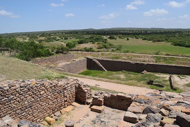
Dholavira, one of the largest cities of the Indus Valley Civilisation, with stepwell steps to reach the water level in artificially constructed reservoirs
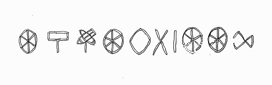
Ten Indus characters from the northern gate of Dholavira, dubbed the Dholavira Signboard
Coat of Arms of Princely State of Cutch dating back to 1893 CE
Flag of the Princely State of Cutch Geography
:
Rivers
and dams :
Divisions
:
Under the Kutch princely state, Kutch was divided into Bani, Abdasa, Anjar, Banni, Bhuvad Chovisi, Garado, Halar Chovisi, Kand, Kantho, Khadir, Modaso, Pranthal, Prawar, and Vagad.
Kutch District is divided into ten talukas: Abdasa (Abdasa-Nalia), Anjar, Bhachau, Bhuj, Gandhidham, Lakhpat, Mandvi, Mundra, Nakhatrana, and Rapar.
Mineral :
Kutch is a mineral rich region with a very large reserve of Lignite, Bauxite, Gypsum and other minerals. Kutch received tax break for industries for 15 years after the major earthquake on 26 January 2001. Lignite is mined only by Gujarat Mineral Development Corporation (GMDC) at its two mines in Panandhro and Mata no Madh. The Panandaro mines has now been reserved for GEB and GMDC power plants and GMDC has stopped supplying other industries from there.
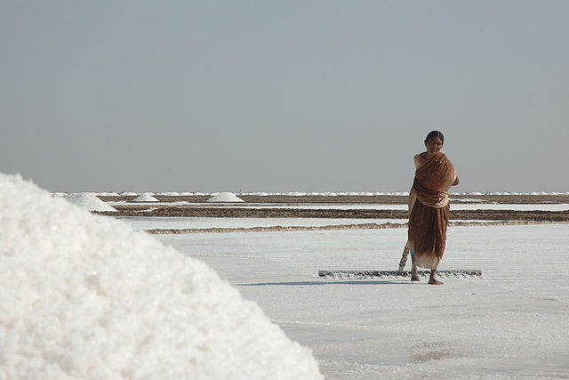
Salt :
Salt worker in Rann of Kutch The Little Rann of Kutch is known for its traditional salt production and various references mention this to be a 600-year-old activity. During the British period, this activity increased manifold. It was used to fund a substantial part of the military expenses of the British government.
Communities involved in salt production are mainly Chunvaliya Koli, Ahir and Miyana (Muslim), residing in 107 villages in the periphery of Lesser Rann of Kutch. These communities are traditionally known to have the skills of salt production and are known as 'Agariyas'. Water quality in 107 villages of Lesser Rann of Kutch is saline, thus agriculture is not an option. Hence salt production is the only livelihood option for Agariyas. As per the Salt Commission's report there are 45000 Agariyas working in the salt pans of Kutch. Out of the estimated total annual production of India of about 18 million tonnes, Gujarat contributes 75% – mainly from Kutch and other parts of Saurashtra.
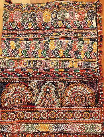
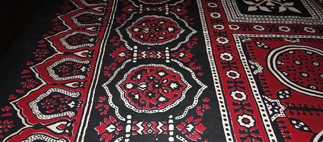
Textile Art :
An example of Kutch Embroidery – Antique Dowry Bag
Ajrak Kutch is one of the most prolific regions in India in the area of textile art. Kutch embroidery is dense with motifs, and a variation with mirrors sewn into the embroidery is one of the signature arts of this region.[citation needed]
Within the category of Kutch embroidery there are several sub-categories as each tribe and sub-tribe produces a unique signature form of art.
Kutch embroidery is an evolving expression of the craft and textile traditions of the Rabaris, a nomadic tribe in Gujarat. Kutch embroidery is unique in the sense that a net is woven on a cloth using thread.The net is then filled in using the same thread by intricate interlocking stitches. The patterns are usually built around geometric shapes.This embroidery follows its own traditional design logic and juxtaposition of colours and motifs. The Rohanas tribals of Kutch specialise in skirt work. The Sodhas use a geometric style for their embroidery. The Garacia Jats are experts in tiny embroidery on the yoke, which intermingles with red, orange, blue and green threads. The Dhanetah Jats love embroidering broad pear-shaped mirrors using orange, black, yellow and red in chain stitch.
Source :
https://en.wikipedia.org/ |