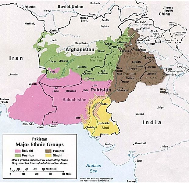
| BALOCHISTAN
Map with Hakra Ware sites in red Countries : Afghanistan, Iran and Pakistan
Population (2013)
Total : c. 18 - 19 million
Demographics
Ethnic groups : Baloch
Languages : Balochi, Minor: Brahui, Pashto, Persian, Urdu
Largest cities : • Quetta • Turbat • Zahedan • Khuzdar • Zaranj • Uthal • Iranshahr • Dera Allah Yar • Sibi • Kalat • D.M. Jamali • Dera Bugti • Gwadar • Chabahar • Nushki
Balochistan is an arid desert and mountainous region in south-western Asia. It comprises the Pakistani province of Balochistan, the Iranian province of Sistan and Baluchestan, and the southern areas of Afghanistan, including Nimruz, Helmand and Kandahar provinces. Balochistan borders the Pashtunistan region to the north, Sindh and Punjab to the east, and Persian regions to the west. South of its southern coastline, including the Makran Coast, are the Arabian Sea and the Gulf of Oman.
Etymology
:
Johan Hansman relates the term "Baloch" to Meluhha, the name by which the Indus Valley Civilisation is believed to have been known to the Sumerians (2900–2350 BC) and Akkadians (2334–2154 BC) in Mesopotamia. Meluhha disappears from the Mesopotamian records at the beginning of the second millennium BC. However, Hansman states that a trace of it in a modified form, as Baluhhu, was retained in the names of products imported by the Neo-Assyrian Empire (911–605 BC). Al-Muqaddasi, who visited the capital of Makran - Bannajbur, wrote c. 985 AD that it was populated by people called Balusi (Baluchi), leading Hansman to postulate "Baluch" as a modification of Meluhha and Baluhhu.
Asko Parpola relates the name Meluhha to Indo-Aryan words malech (Sanskrit) and milakkh / milakkhu (Pali) etc., which do not have an Indo-European etymology even though they were used to refer to non-Aryan people. Taking them to be proto-Dravidian in origin, he interprets the term as meaning either a proper name milu-akam (from which tamilakam was derived when the Indus people migrated south) or melu-akam, meaning "high country", a possible reference to Balochistani high lands. Historian Romila Thapar also interprets Meluhha as a proto-Dravidian term, possibly melukku, and suggests the meaning "western extremity" (of the Dravidian-speaking regions in the Indian subcontinent). A literal translation into Sanskrit, aparanta, was later used to describe the region by the Indo-Aryans.
During the time of Alexander the Great (356–323 BC), the Greeks called the land Gedrosia and its people Gedrosoi, terms of unknown origin. Using etymological reasoning, H. W. Bailey reconstructs a possible Iranian name, uadravati, meaning "the land of underground channels", which could have been transformed to badlaut in the 9th century and further to baloc in later times. This reasoning remains speculative.
History :
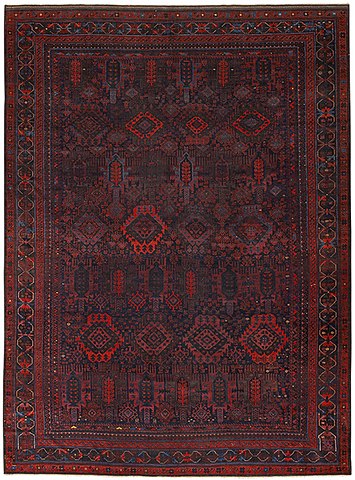
Large
Baluch carpet, from the mid 19th century. Alternating rows depict
cypress trees and Turkmen Gül motifs in offset coloration.
The somber background colors are characteristic of Baluch weavings.
This likely was a commission for a tribal Khan or chieftain for
ceremonial use.
From the 1st century to the 3rd century CE, the region was ruled by the Paratraj's (lit. "Parat Kings"), a dynasty of Indo-Scythian or Indo-Parthian kings. The dynasty of the Parats is thought to be identical with the Parads of the Mahabharat, the Purans and other Vedic and Iranian sources. The Parat kings are primarily known through their coins, which typically exhibit the bust of the ruler (with long hair in a headband) on the obverse, and a swastik within a circular legend on the reverse, written in Brahmi (usually silver coins) or Kharoshthi (copper coins). These coins are mainly found in Loralai in today's western Pakistan.
Herodotus in 450 BCE described the Paraitakenoi as a tribe ruled by Deiokes, a Persian king, in northwestern Persia (History I.101). Arrian describes how Alexander the Great encountered the Pareitakai in Bactria and Sogdiana, and had them conquered by Craterus (Anabasis Alexandrou IV). The Periplus of the Erythraean Sea (1st century CE) describes the territory of the Paradon beyond the Ommanitic region, on the coast of modern Balochistan.
The Hindu Sewa Dynasty ruled parts of Balochistan, chiefly Kalat. The Sibi Division, which was carved out of Quetta Division and Kalat Division in 1974, derives its name from Rani Sewi, the queen of the Sewa dynasty.
The region was fully Islamized by the 9th century and became part of the territory of the Saffarids of Zaranj, followed by the Ghaznavids, then the Ghorids. Ahmad Shah Durrani made it part of the Afghan Empire in 1749. In 1758 the Khan of Kalat, Mir Noori Naseer Khan Baloch, revolted against Ahmed Shah Durrani, defeated him, and freed Balochistan, winning complete independence.
In the 1870s, Baluchistan came under control of the British Indian Empire in colonial India. During the time of the Indian independence movement, "three pro-Congress parties were still active in Balochistan's politics", such as the Anjuman-i-Watan Baluchistan, which favoured a united India and opposed its partition.
Governance
and political disputes :
In Pakistan, insurgencies by Baloch nationalists in Balochistan province have been fought in 1948, 1958–59, 1962–63 and 1973–1977 – with a new ongoing and reportedly stronger, broader insurgency beginning in 2003. Historically, drivers of the conflict are reported to include "tribal divisions", the Baloch-Pashtun ethnic divisions, "marginalization by Punjabi interests", and "economic oppression".
In Iran, separatist fighting has reportedly not gained as much ground as the conflict in Pakistan, but has grown and become more sectarian since 2012, with the majority-Sunni Baloch showing a greater degree of Salafist and anti-Shia ideology in their fight against the Shia-Islamist Iranian government.
Source :
https://en.wikipedia.org/ |