| RAVI RIVER
Ravi River
Ravi River Location
Ravi River Country
: India, Pakistan
Length : 720 km (450 mi)
The Ravi River is a transboundary river crossing northwestern India and eastern Pakistan. It is one of six rivers of the Indus System in Punjab region (Punjab means "Five Rivers").
Under the Indus Waters Treaty of 1960, the waters of the Ravi and two other rivers were allocated to India. Subsequently, the Indus Basin Project was developed in Pakistan, which transfers waters from western rivers of the Indus system to replenish the Ravi. Many inter-basin water transfers, irrigation, hydropower and multipurpose projects have been built in India.
History
:
Part of the battle of the ten kings was fought on a river, which according to Yaska (Nirukta 9.26) refers to the Iravati River (Ravi River) in the Punjab.
Geography
:
River course :
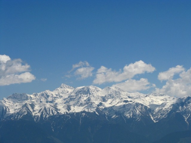
Pir Panjal Range
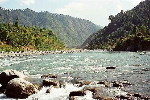
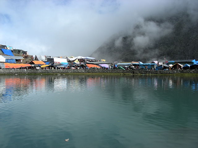
Source of Budhil River, in Himachal Pradesh a major tributary of the Ravi River The Ravi River originates in the Himalayas in the Multhan tehsil of Kangra district of Himachal Pradesh, India. It follows a north-westerly course and is a perennial river. It is the smallest of the five Punjab rivers that rises from glacier fields at an elevation of 14,000 feet (4,300 m), on the southern side of the Mid Himalayas. It flows through Barabhangal, Bara Bansu and Chamba districts. It flows in rapids in its initial reaches with boulders seen scattered in the bed of the river. The Ravi River in this reach flows in a gorge with a river bed slope of 183 feet per mile (34.7 m/km) and is mostly fed by snow melt, as this region lies in a rain shadow. Two of its major tributaries, the Budhil and Nai or Dhona join 64 kilometres (40 mi) downstream from its source. The Budhil River rises in Lahul range of hills and is sourced from the Manimahesh Kailash Peak and the Manimahesh Lake, at an elevation of 4,080 metres (13,390 ft), and both are Hindu pilgrimage sites. The entire length of Budhil is 72 kilometres (45 mi) where it has a bed slope of 314 feet per mile (59.5 m/km). It flows through the ancient capital of Bharmwar, now known as Bharmour in Himachal Pradesh. During 1858–1860, the Raja of Bharmour had considered the Budhil valley as an excellent source of Deodar trees for supply to the British Raj. However, a part of the forest surrounding the temple was considered sacred and declared a reserved area. The second tributary, the Nai, rises at Kali Debi pass, and flows for 48 kilometres (30 mi), with a bed slope of 366 feet per mile (69.3 m/km), from its source at Trilokinath to its confluence with the Ravi. This valley was also exploited for its forest wealth during the English period.
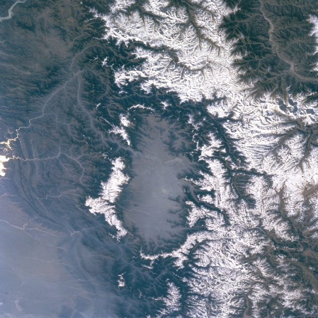
Kashmir valley seen from satellite. Eastern sector of snow-capped Pir Panjal range separates Beas and Ravi River basins from the Chenab valley Another major tributary that joins the Ravi River, just below Bharmour, the old capital of Chamba, is the Seul River from the northern direction. The valley formed by the river was also exploited for its rich timber trees. However, the valley has large terraces, which are very fertile and known as "the garden of Chamba". crops grown here supply grains to the capital region and to Dalhousie town and its surrounding areas. One more major tributary that joins the Ravi River near Bissoli is the Siawa. This river was also exploited for its forest resources, (controlled by the then Raja of Chamba) originating from the Jammu region. The valley is also formed by another major tributary that joins Seul River, the Baira-Nalla. Its sub-basin is in the Chamba district, located above Tissa. Baira drains the southern slopes of the Pir Panjal Range. The valley has an elevation variation between 5,321 metres (17,457 ft) and 2,693 metres (8,835 ft).
Tant Gari is another small tributary that rises from the subsidiary hill ranges of the Pir Panjal Range east of Bharmour. The valley formed by this stream is U-shaped with a river bed scattered with boulders and glacial morainic deposits.
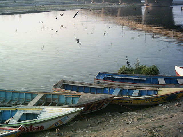
Boats floating beside the Ravi River in Lahore
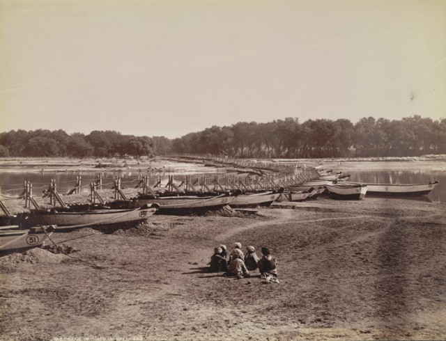
Bridge of boats on the Ravi taken by unknown photographer in 1880 Main
Ravi River :
Ujh River is another major tributary of the Ravi River. Its source is in the Kailash mountains at an elevation of 4,300 metres (14,100 ft), close to the Bhaderwah Mountains in Jammu district. After flowing for 100 kilometres (62 mi), it joins Ravi at Nainkot in Pakistan.
As the Ravi flows past Lahore in Pakistan (26 kilometres (16 mi) below Amritsar in India) it is called "The river of Lahore" since that city is on its eastern bank. After passing through Lahore the river takes a turn at Kamalia and then debouches into the Chenab River, south of the town of Ahmadpur Sial. On its western bank is the town of Shahdara Bagh with the tomb of Jahangir and the Tomb of Noor Jahan.
Change
of river course :
River
water pollution :
Vegetation
:
Hydrology
:
Pre-partition utilisation :
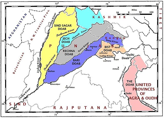
A map of the Punjab region ca. 1947 showing the doabas formed by Ravi River with other rivers of the Indus River system On the Ravi River, the earliest project built was the Madhopur Headworks, in 1902. It is a run-of-the river project (no storage envisaged) to divert flows through the Upper Bari Doab Canal (also known as Central Bari Doab Canal) to provide irrigation in the command area of the then unified India. Government of India has assessed the pre-partition use in India (Punjab) at 1.821 cubic kilometres (1,476,000 acre·ft). Prior to partition, it irrigated 335,000 hectares of land in Gurdaspur, Amritsar and Lahore districts.
Hydropower :
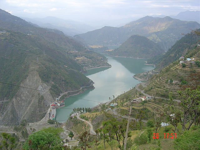
Chamera Lake and dam The Hydropower potential of Ravi River system has been assessed at 2294 MW, of which only 1638 MW has been harnesses cumulatively, thus leaving 656 MW wasted opportunity. The hydropower potential developed since the 1980s is through installation of Baira Suil Hydroelelectric Power Project of 198 MW capacity, the Chamera-I of 540 MW capacity commissioned in 1994, the Ranjitsagar Multipurpose Project of 600 MW capacity completed in 1999 and the Chamera-II of 300 MW capacity in the upstream of Chamera-I commissioned in 2004.
Multipurpose
development :
A proposal for building a storage dam on the Ravi River was initially planned in 1912, envisaging a 61 metres (200 ft) high dam. A committee later conducted a survey of the area, but it was not until 1954 that geologists fully inspected the project area. In 1957, a storage Dam was proposed on the Ravi River for irrigation purposes only. The power generation aspect was not considered then. It was only in 1964 that the project was conceived for multipurpose development and submitted to Government of India for approval. Finally, in April 1982, the project was approved for construction by the Government of India.
The project, as built now, has a 160-metre (520 ft) high earth gravel shell dam with a gross irrigation potential of 348,000 hectares (860,000 acres) of land and power generation of 600 MW (4 units of 150 MW capacity each).
The geomorpohological setting of the river basin, which has a large number of terraces between Dhauladhar and Pir Panjal ranges, is attributed to the truly Himalayan characteristics of the river reflecting the "cis-Himalayan tectonic; structural, lithological and climatic conditions. Obviously it is different from the antecedent Indus and Sutlej".
International water-sharing treaty :
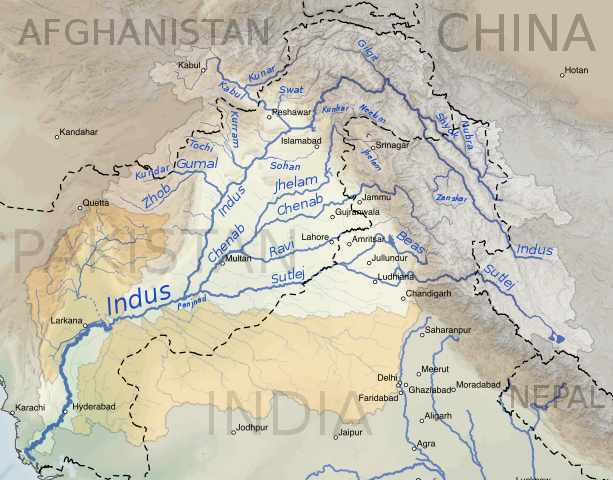
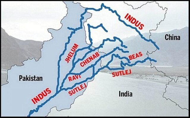
The Indus River system comprising the rivers, Ravi, Beas, Sutlej, Chenab, Jhelum and Indus- a shared legacy between India and Pakistan The upper reaches of the main Indus River and its tributaries lie in India whereas the lower reaches are in Pakistan. Following the partition of India in August 1947, a dispute arose between India and Pakistan on sharing of the waters of the Indus River Basin. The dispute was resolved with the intervention of the World Bank and a treaty was signed in 1960 on sharing of the Indus waters between India and Pakistan.
The Indus System of Rivers comprises the three Western Rivers in the Indus, the Jhelum and Chenab together with three Eastern Rivers; the Sutlej, the Beas and the Ravi. To establish the ownership of these waters, an Indus Water Treaty was signed between India and Pakistan on 1 April 1960, under monitoring of the World Bank. The treaty, under Article 5.1, envisages the sharing of waters of the rivers Ravi, Beas, Sutlej, Jhelum and Chenab which join the Indus River on its left bank (eastern side) in Pakistan. According to this treaty, Ravi, Beas and Sutlej, which constitute the eastern rivers, are allocated for exclusive use by India before they enter Pakistan. However, a transition period of 10 years was permitted in which India was bound to supply water to Pakistan from these rivers until Pakistan was able to build the canal system for utilisation of waters of Jhelum, Chenab and the Indus itself, allocated to it under the treaty. Similarly, Pakistan has exclusive use of the Western Rivers Jhelum, Chenab and Indus but with some stipulations for development of projects on these rivers in India. Pakistan also received one-time financial compensation for the loss of water from the Eastern rivers. Since 31 March 1970, after the 10-year moratorium, India has secured full rights for use of the waters of the three rivers allocated to it. The treaty resulted in partitioning of the rivers rather than sharing of their waters.
Under this treaty, the two countries also agreed to exchange data and co-operate in matters related to the treaty. For this purpose, treaty envisaged creation of the Permanent Indus Commission, with a commissioner appointed by each country. The Indus Waters Treaty is the only International treaty that has been implemented over the last 60 years with due diligence and sincerity by both India and Pakistan, in spite of many wars fought between the two countries (the treaty was not revoked either by India or Pakistan during the 1965 or the 1971 war).
Interstate
water dispute :
As a counter claim to the exclusive claims of Punjab, Haryana claims that a small part of Haryana state lying north in Panchkula district is part of Sutlej river basin area in addition to Punjab and Himachal Pradesh in India. Thus Haryana claims to be a riparian state of Indus river basin.
Following the reorganisation of the state of Punjab in 1966, Haryana State was created. This was followed by a notification by the Government of India dated 24 March 1976 allocating the surplus waters between Punjab and Haryana in due consideration of the powers conferred by Sub Section (I) of Section 78 of the Punjab Reorganization Act, 1966 (31 of 1966). The allocation was challenged in the Supreme Court by Haryana. A tripartite agreement followed on 31 December 1981, based on the revised mean annual flows from the flow series of 1921–60 assessed as 25.36 cubic kilometres (20,560,000 acre·ft)—including prepartition use of 3.86 cubic kilometres (3,130,000 acre·ft) and transit losses in the Madhopur Beas Link of 260,000 acre feet (0.32 km3)—vis-a-vis the figure of 19.55 cubic kilometres (15,850,000 acre·ft) assessed in earlier allocation, which was based on the flow series of 1921–45. The revised assessed surplus supplies of 17,170,000 acre feet (21.18 km3) (from flow and storage) was allocated as :
Share of Punjab 4.22 million acre-ft (MAF); Share of Haryana 3.50 MAF; Share of Rajasthan 8.60 MAF; Quantity earmarked for Delhi Water supply 0.20 MAF; Share of Jammu & Kashmir 0.65MAF with some specific provisions.
However,
the legality of this agreement was challenged by Punjab. This was
followed by the Punjab accord signed by the then Prime Minister
of India Rajiv Gandhi and Sant Harchand Singh Longowal, President
of the Shiromani Akali Dal, on 24 July 1985. This accord stipulated
that
9.2 The claim of Punjab and Haryana regarding the shares in their remaining waters shall be referred for adjudication to a Tribunal to be presided over by Supreme Court Judge. The decision of this Tribunal will be rendered within six months and would be binding on both parties. All legal and constitutional steps in this respect to be taken expeditiously; 9.3 The construction of Sutlej Yamuna Link (S.Y.L.) canal shall continue. The canal shall be completed by August 1986.
Following the above accord, Ravi & Beas Waters Tribunal (RBWT) came to be set up in April 1986, in pursuance of paragraphs 9.1 & 9.2 of Punjab Settlement (Rajiv-Longowal Accord, 1985) inter-alia to adjudicate the claims of Punjab and Haryana in Ravi-Beas waters. The Terms of Reference was set and also the time for submission of the report. The Tribunal submitted its report on 30 January 1987. However, the report was contested as Rajasthan also moved an application "seeking explanation and guidance regarding the report of this Ravi Beas waters Tribunal, 1987". The Tribunal is further examining the matter. It is yet to submit its further report to the Government on the pleas submitted by the party States and the Central Government also seeking explanation/guidance on its earlier report. In the meantime, a Presidential reference on Punjab Termination of Agreements Act, 2004 is pending before the Honorable Supreme Court. Hence, the further hearings of the Tribunal and its final report are now enjoined on the outcome of the Supreme Court hearing of the Presidential reference. The presetnly incomplete SYL link canal, to connect the Sutlej and Yamuna rivers to transfer Haryana's share of water, is now stuck in a dispute in the Supreme Court of India due to objections by Punjab.
Punjab is contemplating to construct 206 MW Shahpurkandi dam project hydro electric project on the Ravi river between Ranjitsagar dam and Madhopur head works. This stretch of the river is forming boundary between J & K state and Punjab state. Since Punjab had unilaterally exited from the earlier water sharing agreements, J & K state refused the project construction. Also J & K state is going ahead with the construction of Ravi canal originating from Basantpur to irrigate 54,000 hectares (133,000 acres) of land in Jammu region. This canal would draw river water by pumping the water released downstream from the Rangitsagar reservoir for which J & K state is not required to take consent from Punjab as it is not bound by earlier river water sharing agreements.
Interbasin
water transfer :
Source :
https://en.wikipedia.org/ |
.png)