| MOURU
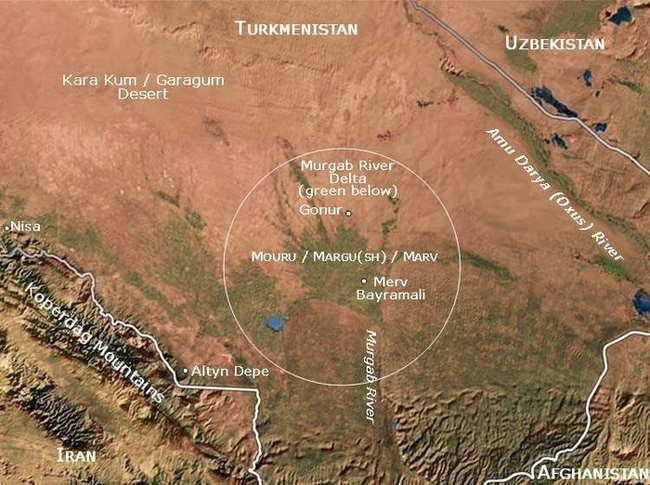
Murgab delta and oasis (circled) in the south of Turkmenistan. The Murgab river spreads out and disappears into the Kara Kum desert to the north The Ancient Civilization of Mouru & the Murgab River Delta :
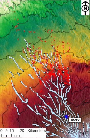
Distribution of archaeological sites (in red) in the Murgab Delta. Photo credit: University of Bologna The environs of Mouru, the third nation listed in the Zoroastrian scriptures, the Avesta's book of Vendidad, are generally thought to have included the Murgab river delta, that is, the region around Merv which today is a city in southern Turkmenistan. Ruins of over 150 ancient settlements dating back to the early Bronze Age (2500-1700 BCE) have been found in the Murgab delta region which covers an area of more than 3000 sq. km. and contains about 78 oases.
Archaeological reports indicate that the earliest agricultural settlements in the Murgab delta could date as far back as the 7th millennium BCE making it a seat of one of the oldest human civilizations - a civilization that Raphael Pumpelly (1837-1923) had sought to bring to the attention of a world more focused on the old civilizations of the Tigris-Euphrates and Nile River valleys, saying, "the fundamentals of European civilization—organized village life, agriculture, domestication of animals, weaving, etc. - were originated on the oases of Central Asia long before the time of Babylon." [Discover Magazine notes: " Volunteer Lisa Pumpelli is working there in a trench at the top of a large mound with a spectacular view of the Kopet-Dag mountains. She is helping Hiebert, who is now an archaeologist with the National Geographic Society in Washington, D.C., track down the precursors to the Oxus culture. Both are following in the footsteps of Lisa Pumpelli's grandfather, Raphael Pumpelly, and great-grandfather, also named Raphael Pumpelly (Pumpelly is an alternate spelling of the family name). "I'm digging in my great-grandfather's back dirt," Pumpelli quips."]
The River Murgab (also spelt Morghab, Murghab - or Murgap in the Turkmen language) originates on the western slopes of the Kuh-e Hissar mountains of northern Afghanistan. After flowing 850 kilometres - first to the west in the valley between Safeed Kuh and Siah Kuh mountains, and then to the north as it leaves Afghanistan to enter Turkmenistan - the once mighty river disperses itself as the fingers of a delta that disappears in the sands of Turkmenistan's Karakum (Garagum) Desert.
Verse 10.14 of the Avesta's Mehr Yasht, states that the rivers which originate in Airyo shayanem, the Aryan abode, flow swiftly into the countries of Mourum [later Margu(sh) (English-Greek Margiana) and eventually Marv located in today's Turkmenistan], Haroyum (Aria in modern Afghanistan), Sughdhem (Sugd in Tajikistan and Uzbekistan) and Khairizem [Khvarizem beside the Amu Darya (Oxus) River in Uzbekistan]. The principal river that flows into Mourum is the Murgab.
Ruins of the earliest of the Murgab delta settlements - those dating from the 3rd and 2nd millennium BCE - have been found in substantial numbers in the northeast of the delta region (see the image to the right) - a region that was once green and fertile but which today has been claimed by the relentlessly spread of the Karakum desert. The northern delta settlements include those now known as the ruins at Kelleli, Adji Kui, Taip, Gonur, and Togolok (Togoluk).
The development of relatively advanced irrigation techniques in the early Iron Age enabled the growth of additional settlements. It is presumed that as the northern delta area became more dry, large metropolises like Gonur were abandoned. Further to the south, the ancient city of Merv became an Achaemenid era (519-331 BCE) administrative centre and perhaps even the capital of the satrapy that included Mouru. Mouru was then known to the Achaemenians as Margu(sh) and to the Greeks as ?a???a??. Margiana is the derived English-Latin name of Margu. The Sassanian name for the region was Marv.
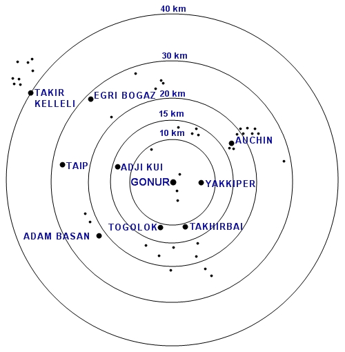
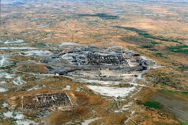
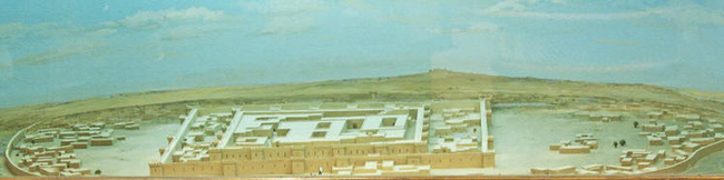
The ruins of Gonur are surrounded by other uncovered ancient settlements identified as dots in the images above and below.
Gonur & surrounding ancient settlements discovered so far. The Region & Zoroastrianism In the list of sixteen nations mentioned in the Zoroastrian scriptures', the Avesta's, book of Vendidad, Mouru or Mourum, is the third. Zarathushtra (Zoroaster) was native to Airyanam Vaeja (Ancient Aryana), the first in the list of the Vendidad-Avesta nations. Even though Zarathushtra was not native to Mouru, it is in the realm of possibilities that he might have preached in Mouru. However, this activity - if it took place - is not mentioned in the scriptures.
In listing the nations listed after Airyana Vaeja, the Vendidad cites non-Zoroastrian traits in many of the nations, suggesting that that the Aryan Zoroastrians possibly lived in multi-cultural multi-faith communities. Because ancient Zoroastrians did not worship in temples, because they did not bury their dead, and because they were careful not to defile the environment with garbage, they would have left scant evidence of their religious activities.
What we learn from the archaeological findings under the tepe or depes in the Murgab region supports the history contained in the Avesta, a history we have outlined in our pages on the Aryans.
Tepe
or Depe :
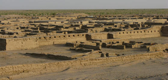
The largest of the settlements uncovered in the north-eastern Murgab delta are the ruins called Gonur-Tepe. We have not read to any layers in this excavation as of this writing though it it quite possible that lower, older, layers await discovery.
Gonur / Gonor/ Gunar
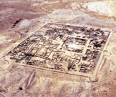
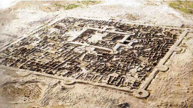
Aerial view of Gonur-Tepe's southern complex. Photo credit: Various. Country Turkmenistan & Stantours
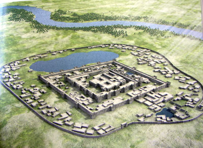
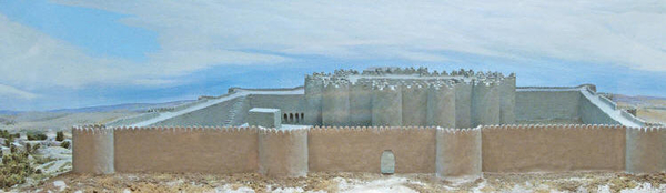
Artist's reconstruction of the Gonur north complex Note the successive protective walls with the outer-most surrounding what appear to be dwellings. We can expect that during an armed attack, citizens would have retreated behind the safety of the inner fortress walls. Artist unknown
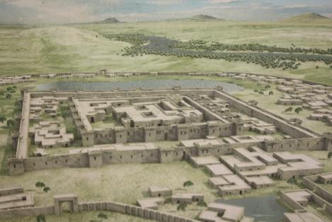
Another reconstruction of the Gonur north complex The largest of all the ancient settlements uncovered in the Murgab delta is Gonur-Depe (or Gonur-Tepe. Gonur is also spelt Gonor or Gunar). Gonur is located some seventy kilometres north of the ruins of Merv and a three-hour drive from Mary. The area around Gonur is now sparsely populated.
The Gonur site occupies an area of about 55 hectares and consists of the main complex in the northern section of the site and a smaller (130 x 120 m = 1.56 hectare) complex to the south.
The southern complex is also said to be 3 hectares in size and that might include surrounding structures.
A large necropolis lies to the west of the site. In the centre of the northern complex is a fortified citadel-like structure. Both complexes have fortification walls. The fortification walls of the southern complex are wide, 8 to 10 metres tall and interspaced with round towers along its sides and corners. There are residential quarters walls within the fortifications.
Aerial photo of Gonur showing both complexes (looking almost directly north). Photo credit: Kenneth Garrett
Reconstruction of the Gonur south fortifications at National Museum of Turkmenistan. Photo credit: Kerri-Jo Stewart at Flickr
Reference:
Excavations at Southern Gonur, by V. Sarianidi, 1993, British
Institute of Persian Studies.
Other web articles include Discover Magazine, Anahita Gallery, Kar Po's Travel Blog, Dan & Mary's Monastery, Archaeology Online, Turkmenistan June 2006 and Stantours. Generally, we find the quality of research and reports available of the web to be poorly researched, highly speculative and sensationalistic.
Photo
sites :
Description of Ancient Gonur :
The people of Gonur were also traders and were likely among those who developed the first trade links between the East and the West along what came to be known as the Silk Roads. The good the traders carried to distant cities included those made from for ivory, gold, and silver. They buried their dead in elaborate graves filled with fine jewellery and wheeled carts.
The north Gonur complex had a central citadel-like structure about 100m by 180m (nearly 350 by 600 feet) in size and surrounded by a high fortification wall and towers. The citadel was set within another vast walled area. This wall had square bastions and was in turn placed within a large oval enclosed walled area that included a large water basins and many dwellings and other buildings.
The archaeologist Viktor Sarianidi (see Sarianidi, page 3) who excavated the ruins, began a trend to call Gonur, Margush (or the capital of Margush), a name used by the Achaemenians for Mouru or Merv a thousand or so years after Gonur had been abandoned. We would prefer to say that Gonur was a major administrative centre and metropolis of Mouru, the older Avestan name for the nation.
Sarianidi also identifies the southern structure as a cathedral-like temple. We strongly doubt this conclusion for Sarianidi's analysis has numerous factual errors and he displays no real knowledge of Zoroastrianism, its doctrine and practice on which he bases many of his conclusions. These errors and lack of understanding (or even an attempt at objective research) brings into question the credibility and veracity of his sensationalistic and outlandish pronouncements about the function of the various structures within the Gonur complexes.
The evidence from the excavations points to the city of Gonur functioning for the relatively short time of a few hundred years after which it was abandoned by its residents.
Water Management :
In addition to the water canals the residents of Gonur had dug from the river to water their fields, the city also had a sophisticated water supply and sewage system. it appears water was brought in to the city. The city also appears that two separate sewage systems, one for ordinary waste water and the other - it is suggested - for water that had been used for the ritual washing of bodies during funerals. Given Sarianidi's other fantastic and ill-informed conclusions about Zoroastrian rites, we must wonder about the veracity of this construct.
Source :
http://www.heritageinstitute.com/ |